Luckily, I now have connection to WIFI, so I can make a more detailed post. There's a lot to get to in this post, so we'll get right to it.
Forming in the last few days of July, Hurricane Isaias ravaged the East coast, producing extensive damage, taking lives, and causing widespread power outages.
 |
| Isaias storm track (Weather.com) |
Isaias impacted the Dominican Republic and Puerto Rico first, producing up to 13 inches of rain in the former and over 10 inches of rain in parts of the latter. Progressing northward, the storm impacted the Bahamas, where gusts up to 69 mph were recorded.
On August 2, Isaias impacted Florida with heavy rains and winds, though it did not make landfall in the state. Interestingly, Florida halted all Covid-19 testing efforts due to the storm. It'll be interesting to see how this impacts the spread of the virus. Isaias officially made landfall on August 3 at 11:10 p.m. near Ocean Isle Beach, NC as a category 1 hurricane, with wind gusts of 99 mph recorded.
 |
| Isaias observed peak wind gusts (NWS) |
As a result of the deluge of rain and hurricane-force winds that Isaias brought, coastal areas saw extensive storm surge and flooding. Isaias progressed northward at the start of the work week, affecting some of the most populous areas of the country. New Jersey was one of the hardest hit areas, with winds gusting to over 70 mph.
 |
| Isaias observed peak wind gusts (NWS) |
This of course caused significant damage, knocking down power lines and downing trees. At its peak, there were nearly 600,000 power outages in my home state of Connecticut, a representing a large fraction of the state.
 |
| Power outage map as of yesterday at 5:11 p.m. (PowerOutage.US) |
As of yesterday, many customers were still out of power, with Connecticut being the hardest hit state. The number in CT has dropped to 474,618 without power as of this morning. I have heard reports that Eversource, one of CT's main power providers, expects power for 99% of customers to be restored by Tuesday.
Another impact of Isaias was the torrent of rain that it brought.
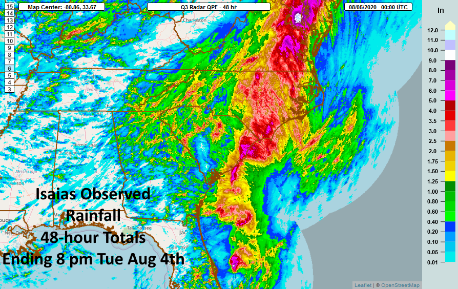 |
| Isaias observed rain (NWS) |
In the mid-Atlantic, one area along the Maryland-Virginia border saw nearly 10 inches of rain!
 |
| Isaias observed rain (NWS) |

 Isaias caused incredible damage and it will go down in history as one of the more crippling storms that New England has seen. In my life time, I'd put this storm on par with the October 2011 snowstorm, Hurricane Sandy, and Hurricane Irene. It'll be a slow and long cleanup, but we will get through this.
 |
| August 6 update to 2020 Atlantic hurricane season outlook |
No comments:
Post a Comment