Happy Sunday! While northern New England is mostly clear today, it's a dreary Sunday here in southern New England. The rain we have been seeing is definitely not a drought-buster, but it is much needed. Also, temperatures right now in southern New England sit in the 60s (!), while there is a sharp temperature gradient, as parts of the Adirondacks are in the upper 70s.
 |
| Current temperatures (NWS) |
Looking ahead to the coming week, it'll likely be one of the nicest weeks of the summer, with cooler temperatures, less humidity, and abundant sunshine. Aside from some possible showers on Tuesday, the GFS is showing clear weather for the entire week.
 |
| GFS precip through Saturday (Tropical Tidbits) |
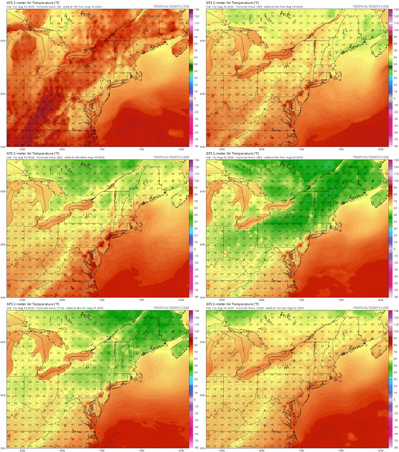
Note the area of high pressure that moves through the region later in the week on Thursday. That means that we'll see clear, stable weather with some nice and comfortable temperatures. For me, the exciting thing about this week's weather is the respite from the seemingly relentless heat and humidity that we've had this summer. Here are the week's surface temperatures, as shown by the GFS.
 |
| GFS 2-m temperatures through Saturday (Tropical Tidbits) |
With daytime highs in the upper 70s or low 80s and overnight lows dropping into the 50s this week, it'll simply feel fantastic. I even think that some upper elevation areas of northern New England could see the temperature drop into the upper 30s during the week. We'll be getting a nice taste of fall. The humidity also goes away later in the week. Here are the GFS dew points for Thursday morning, with the entire region seeing values in the 40s.
 |
| GFS dew points for Thursday at 8 a.m. (Tropical Tidbits) |
That is drier air that is much more reminiscent of what we see in autumn, so it'll feel fantastic. Although it's still a few days out, I think Thursday is the choice day of the week as that area of high pressure moves through our region.
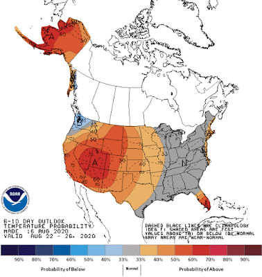
That cooler, more comfortable air than what we've been seeing will likely stick around as we head into the latter parts of August. Here's the Center for Climate Prediction's (CPC) 6-10 day temperature outlook, showing that the eastern portion of the U.S. will likely experience near normal temperatures for the period from August 22-26.
 |
| 6-10 day temperature outlook (CPC) |
The climatology tells us that things start to cool off as we head throughout August and begin losing more sunlight, so it is no surprise that temperatures will begin to trend cooler. In Hartford, CT, the sun will set at 7:48 p.m. today, and in just one month it'll set at 6:57 p.m. During August and September especially, we start to lose sunlight hours fast. With that, we'll begin to see comfortable weather typical of fall, and we'll get our first taste of it this week.
No comments:
Post a Comment