Here is part 2 of my recap of major weather or climate related events of 2020. For part 1, see this
link.
4. Major Northeast Winter Storm on 12/16 to 12/17
As someone who loves winter weather, I simply had to include this storm in my top 10 weather events.
The above NWS Eastern Region tweet shows the impressive snowfall totals from this storm. 4 states saw over 40" of snow, as shown in the above tweet. Additionally, pending approval form the National Weather Service and Vermont state climatologists, a 44.8" snowfall report from Peru, VT would set a new 24 hour snowfall record for the state.
The narrow band in the image of the above tweet shows where the heaviest band of snow formed. I found it particularly fascinating that a place like Ludlow in southern Vermont saw 40+ inches of snow, while just about 40 miles north less than five inches fell. If you watch the radar movie below carefully, you will notice the heavy band of snow in New York, southern VT and southern NH at around 5:00 AM EST. This heavy precipitation appears as the dark green and yellow colors on this radar loop.
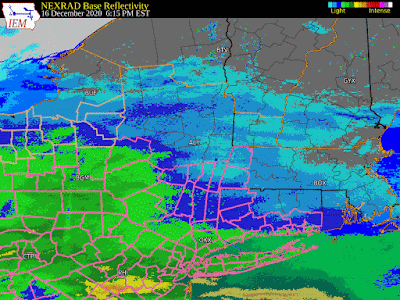 |
| Dec 16-17 winter storm radar (Iowa Environmental Mesonet) |
Additionally, the timing of this storm was incredible. Snow started to pick up in Pennsylvania and western New York in the afternoon on December 16. By mid-day on the 17th, most of the storm had already departed New England. Heavy snowfall rates contributed to the impressive snowfall totals in such a short period of time.
5. Record Heat
While not one individual event, I'd be remiss to not discuss this year's extreme heat here in the Northeast, in the United States, and in the entire world. More so than past years, 2020 showed that global warming is happening and it is a problem that we must put our resources towards tackling.
Here in the Northeast, 2020 has been one of the hottest years on record for many locations. As the figure below shows, almost the entire Northeast had its yearly mean temperature in the 90th or greater percentile.
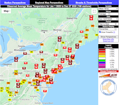 |
| Year to date temperature percentiles (Southeast Regional Climate Center) |
Focusing specifically on Hartford, CT, close to where I was based for much of the year, 2020 has been the second warmest year on record, following 2012.
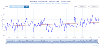 |
| (NOAA Regional Climate Centers/xmACIS) |
The following 2020 temperature chart for the Hartford are shows that while we did have some cooler-than-normal days, temperatures this year were mostly above average, especially during the summer.
 |
| (NOAA Regional Climate Centers/xmACIS) |
Shifting our focus to the country as a whole, the same trends that we saw here in the Northeast were experienced for much of the country. As the following map shows, most of the U.S. saw above normal temperatures, with this trend being especially evident in the Northeast and Southwest.
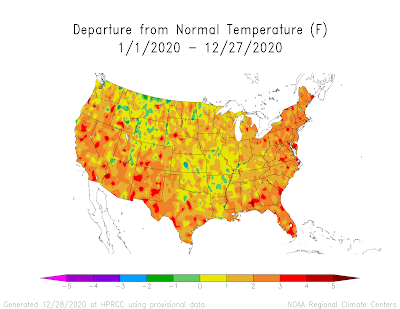 |
| (High Plains Regional Climate Center) |
And to focus on two specific location, Phenix had 156
consecutive days where the temperature was greater than 90 °F this year, and Las Vegas had 61
consecutive days where the temperature was greater than 1001 °F!
Globally, while the year has not yet ended, we are on track to have one of our hottest years on record, consistent with trends over the past 20 years.
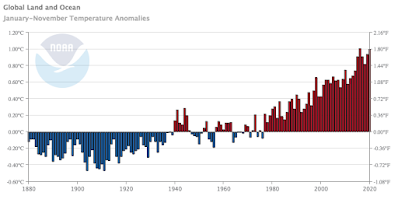 |
| Time series plot of global temperature anomalies (NOAA) |
I could go on and on about how warm it has been this year, but for the sake of brevity, I'll stop here.
6. Midwest Derecho
Often misnamed "land hurricanes" derechos are meteorological phenomena consisting of severe thunderstorms, extreme straight-line winds, and heavy rains that can cause significant damage.
On August 10-11 this summer, a derecho struck Nebraska, South Dakota, Iowa, Illinois, Wisconsin, and Indiana, traveling 770 miles, causing multiple tornadoes, wind gusts estimated to be around 140 mph, hail 2 inches in diameter, and 4 fatalities. See radar reflectivity at one-hour time steps below. The derecho was especially potent in central Iowa, where locations lost power for up to ten days.
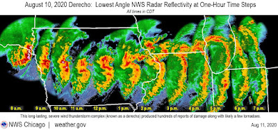 |
| (NWS Chicago) |
See this YouTube video from Evan Hindman, showing just how fast the straight-line winds from the derecho were.
According to a NWS Quad Cities
report on the storm, a derecho of the intensity seen on August 10 is a "once-in-a-decade occurrence for [that] region." Extreme winds prevailed for 30-60 minutes, rather than a more typical 10-20 minutes, according to the NWS Quad Cities.
7. Bomb Cyclone Blizzard in Newfoundland
For most, this event would probably not stand out as a "top 10" weather or climate event for 2020, but for those that live in Newfoundland, Canada, it certainly does.
Far east of the United states in the Canadian province of Newfoundland and Labrador, the pressure dropped 54 mb (!) in 24 hours, forming what is known as "bombogenesis". In this blizzard, winds neared 100 mph, and the city of St. John set a 24 hour snowfall record of 30". Many lost power and a state of emergency was declared for the region. This storm particularly stuck out to be because of the incredible photos and videos from its aftermath. I'll let them speak for themselves:
 |
| (Andrew Vaughan/AP/Shutterstock) |
That's all for part 2 of my top 10 weather and climate related events for 2020. I'll have the final 3 events at some point soon.


