We're seeing a small wintery tease today, with a mix of sleet, rain, and snow, but this batch of precipitation will be rather inconsequential, amounting to maybe an inch or two of snow at higher elevations.
The main action for the week comes Wednesday afternoon, when an area of low pressure will track along the Atlantic Coast. Here is where things stand:
Timing
The first impacts of the storm will be felt on Wednesday afternoon, as the area of low pressure moves north up the Atlantic Coast.
 |
| (Tropical Tidbits) |
The brunt of snow will fall overnight on Wednesday, before the storm moves out to sea by late Thursday morning, with snow gradually tapering off in western areas first.
 |
| (Tropical Tidbits) |
Conditions
As shown in the above figures, during the storm there will be a high located to our north in Canada as well as northerly winds that will deliver the cold air needed to produce wintery weather. This will cause the storm to be an all-snow event, with maybe some areas along the shore seeing some mixing.
 |
| (Tropical Tidbits) |
The blue lines in the above figure are contour lines that show where temperatures will be below 32 °F.
Strong winds with gusts approaching 40 mph are possible, especially in coastal areas, though the exact wind speeds will depend on the strength of the low when it reaches our region.
 |
| (Tropical Tidbits) |
These winds could cause blizzard conditions and power outages for some.
Snowfall totals
While major models are in agreement that we will see snowfall this week, the Euro and GFS have both been disagreeing on the track of the storm, leading to discrepancies about total snowfall accumulations that we'll see. The GFS has taken the more southerly track, with heavier accumulations in New Jersey and Pennsylvania.
 |
| (Tropical Tidbits) |
The European model, on the other hand, has been consistent on the storm taking a more northern track, with significant probabilities of seeing more than 6 inches of snow.
 |
| (WeatherBELL) |
I favor the EURO a bit more, and I think that there's a very solid chance we'll see more than 8 inches of snow. As the storm approaches, we'll have more certainty about this.
It'll be exciting to see our first true snowstorm of the season this week, though it'll be interesting to see what track it takes and what the impacts are. Much of the east has seen less than normal snowfall so far this year, and the snow that we see this week will likely change that.
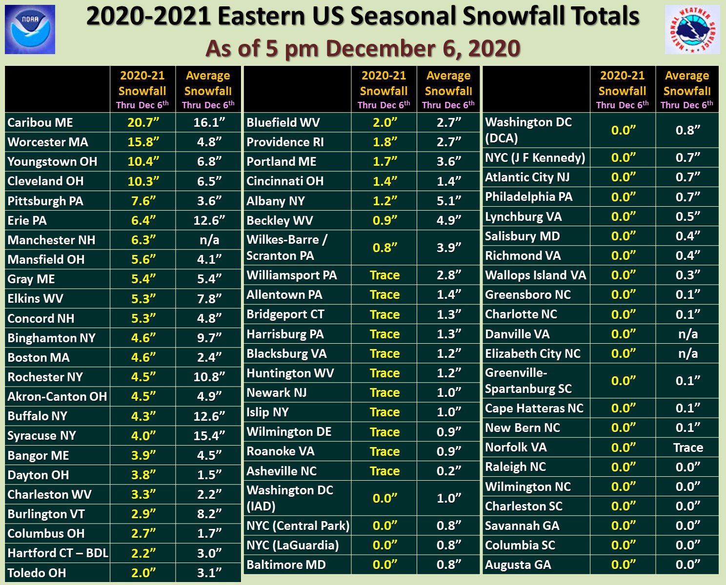 |
| (NWS Eastern Region) |
Update 5:12 p.m.
The National Weather Service has released it's first snow maps, and here is what the organization is thinking.
 |
| (NWS Boston) |
No comments:
Post a Comment