Tropical Storm Isaias is making its way up the Atlantic Coast, wreaking havoc on many areas. Here's my Tuesday midday update on the storm.
 |
Atlantic Tropical Cyclones and Disturbances (NHC)
|
Location: Isaias is currently located in the mid-Atlantic region, moving northeast at around 30 mph.
Timing for New England: The rain has already arrived for much of New England, and it will continue overnight before clearing tomorrow. The following National Hurricane Center (NHC) graphic shows that tropical storm force winds will likely reach Southern New England within the next hour.
 |
| Most likely arrival of tropical-storm-force winds (NHC) |
Rainfall: Rain will be heavy and consistent, with periods of 1 - 1.5 inches of rain falling per hour. The highest rainfall totals will likely remain to the west of New England along the storm track, but certain areas could see up to 5 inches of rain.
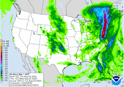 |
24 hour QPF (WPC)
|
And of course, when you see rain this consistent and heavy, flash flooding threats exist, especially near bridges and urban areas.
 |
Risk of flash flooding (NHC)
|
Winds: Winds have picked up in Southern New England, with gusts reaching 50 mph in spots. This can cause downed power lines and lead to power outages throughout New England. The areas with the highest risk for hurricane-force winds include coastal areas and the islands off Massachusetts. Watch out for storm surge in coastal areas as well.
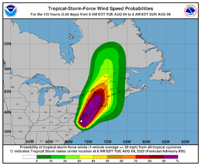 |
Tropical-Storm-Force wind speed probabilities (NHC)
|
Tornado threat: One of the most interesting aspects of Isaias is that conditions are ripe for tornadoes. The Storm Prediction Center (SPC) has given some areas a 10% probability of a tornado based on the atmospheric conditions, which is unusually high for here in the Northeast.
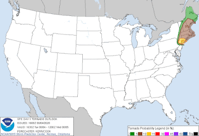 |
Tornado threat (SPC)
|
Summary: Isaias is a powerful storm that is currently moving north along the Atlantic Coast. Rainfall will be heavy at times, with up to 4 or 5 inches falling in spots. Watch out for flooding. Winds will be heavy, causing possible power outages. And tornado watches are in effect for many areas. Stay safe!


No comments:
Post a Comment