Fay, the 6th named tropical storm of the year, is set to impact us in New England this weekend. Here's a nice satellite view of the storm preceding north along the Atlantic coast.
 |
| GOES satellite imagery showing Fay preceding northward (NOAA) |
Right now, the storm is located near Delaware, and it is moving north at around 10 mph.
 |
| Current Atlantic tropical cyclones and disturbances (NHC) |
First let's talk timing of the storm. The following image shows the National Hurricane Center (NHC) storm cone, showing Fay's progression.
 |
| Fay forecast cone (NHC) |
The S that you see in the black dots on the map indicates that sustained winds will be between 39 and 73 mph, making Fay a true tropical storm, and it'll become a tropical depression by Saturday afternoon. As previously mentioned, the storm is currently located around Delaware and it is moving northward. I expect some initial rain to begin in Southern New England this afternoon, picking up in intensity as the storm moves northward. The center of the storm will reach Southern New York overnight tonight, and that's when I'd expect the strongest rain and winds. As Saturday progresses, Fay will continue to penetrate New England, though it should lose it's tropical storm characteristics (39-73 mph winds) by Saturday afternoon.
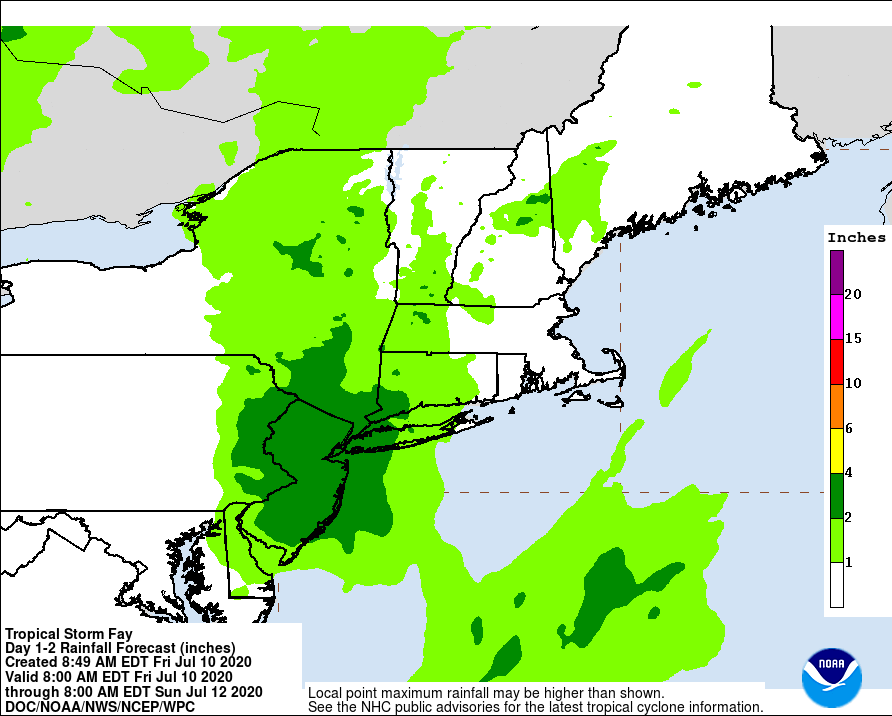
Let's talk about potential impacts of the storm, the biggest one being rain. I think New Jersey and New York will receive the brunt of the rain, with areas of Southwest Connecticut and Eastern Pennsylvania seeing significant rainfall totals as well. I'd expect widespread rainfall totals of 2 to 4 inches, and the NHC is even forecasting up to 7 inches of rain at isolated maxima along the storm track.
 |
| U.S. rainfall QPF (NHC) |
This rainfall will be much needed when it comes to lessening the abnormally dry conditions that we're seeing throughout New England, though when we see rainfall totals this significant, flash flooding becomes a threat. Any areas that see a quick burst of rainfall or urban areas are especially susceptible to flash flooding.
The next big impact is the wind. This image shows the probability that areas will see tropical-storm- force winds. Here in New England, CT looks to have the greatest chance of winds greater than or equal to 39 mph.
 |
| Tropical-storm-force wind speed probabilities (NHC) |
As Fay progresses northwards and we have a better sense of the characteristics of the storm, I'd expect these probabilities released by the NHC to increase. Due to the heavy sustained winds, power outages and downed trees are possible. Overall, I think winds and rain are the biggest threats associated with Fay, but minor coastal flooding and isolated tornadoes near coastal areas of New Jersey, New York, Connecticut cannot be ruled out.
To sum, we can expect rain and heavy winds this afternoon, with the brunt of the storm coming overnight tonight. Flash flooding and potential damage due to winds are possible.
I plan to make this my only post today, but if there are any drastic changes in the forecast, I'll be sure to update.


Thanks for the alert of the incoming significant weather.
ReplyDelete