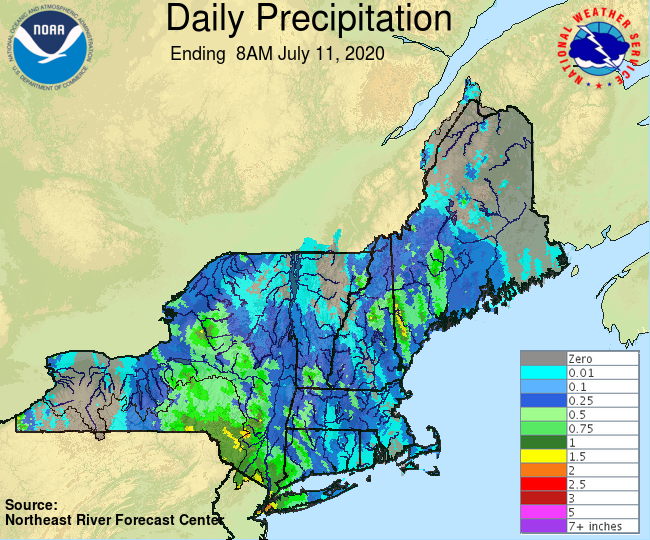
Tropical storm Fay has dissipated and we are back into the typical summertime pattern of hot and muggy weather. I'd say Fay was a bit of an underperformer here in New England, though we did see some impressive wind gusts. Here's a look at rainfall totals from the storm.
 |
| 24 hour observed Northeast precipitation (NWS) |
 |
| 48 hour observed Mid-Atlantic precipitation (NWS) |
As you can see from the above maps (sorry they follow a slightly different color scheme and scale), highest precipitation totals were observed right in the center of the storm track in Delaware, New Jersey, Southeast New York, and Eastern Pennsylvania. Highest totals were in the 5 to 6 inch range, and I saw images and videos of significant flooding at New Jersey beach towns. Stepping outside my house, I definitely noticed the strong winds, which caused some small tree branches to break. Here's a look at peak wind gusts from the storm. Similar to rainfall, the highest winds were observed in NJ and DE.
 |
| Fay peak wind gusts (NWS) |
With the storm having passed through, it's time to look ahead to next week, and the big story is the heat and humidity. Here's a GIF showing the GFS forecasted temperatures throughout the week.
 |
| GFS temperatures for this week through Thursday (Tropical Tidbits) |
I think we'll get into the 80s just about every day. Notice some of the purplish colors in mid-Atlantic areas. Those are temperatures that are well in the 90s, making it feel brutal at times. Here is the same GIF but for dew points. Just about every day this week dew points will be in the upper 60s or low 70s, making it feel oppressive.
 |
| GFS temperatures for this week through Thursday (Tropical Tidbits) |
It isn't until Wednesday that we start to see drier, more comfortable air enter our region. Enjoy the rest of your weekend!


No comments:
Post a Comment