Friday, August 7, 2020

Unpacking Isaias

Luckily, I now have connection to WIFI, so I can make a more detailed post. There's a lot to get to in this post, so we'll get right to it. 

Forming in the last few days of July, Hurricane Isaias ravaged the East coast, producing extensive damage, taking lives, and causing widespread power outages.

Isaias storm track (Weather.com)

Isaias impacted the Dominican Republic and Puerto Rico first, producing up to 13 inches of rain in the former and over 10 inches of rain in parts of the latter. Progressing northward, the storm impacted the Bahamas, where gusts up to 69 mph were recorded.

On August 2, Isaias impacted Florida with heavy rains and winds, though it did not make landfall in the state. Interestingly, Florida halted all Covid-19 testing efforts due to the storm. It'll be interesting to see how this impacts the spread of the virus. Isaias officially made landfall on August 3 at 11:10 p.m. near Ocean Isle Beach, NC as a category 1 hurricane, with wind gusts of 99 mph recorded.

Isaias observed peak wind gusts (NWS)

As a result of the deluge of rain and hurricane-force winds that Isaias brought, coastal areas saw extensive storm surge and flooding. Isaias progressed northward at the start of the work week, affecting some of the most populous areas of the country. New Jersey was one of the hardest hit areas, with winds gusting to over 70 mph. 

Isaias observed peak wind gusts (NWS)

This of course caused significant damage, knocking down power lines and downing trees. At its peak, there were nearly 600,000 power outages in my home state of Connecticut, a representing a large fraction of the state. 

Power outage map as of yesterday at 5:11 p.m. (PowerOutage.US)

As of yesterday, many customers were still out of power, with Connecticut being the hardest hit state. The number in CT has dropped to 474,618 without power as of this morning. I have heard reports that Eversource, one of CT's main power providers, expects power for 99% of customers to be restored by Tuesday.

Another impact of Isaias was the torrent of rain that it brought.
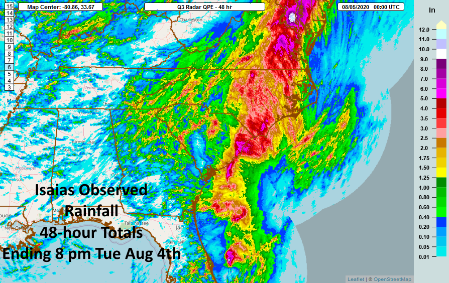
Isaias observed rain (NWS)

In the mid-Atlantic, one area along the Maryland-Virginia border saw nearly 10 inches of rain!

Isaias observed rain (NWS)

In spite of the flooding and crippling damage that Isaias caused in some areas, the rain was much needed, given the dry summer we've had so far. In the above rainfall maps, notice that the areas of heaviest rain fell directly along Isaias' storm track.

I think more telling than rainfall totals or windspeeds are photos of the shear damage that Isaias engendered. Here are some photos from my town.
Isaias caused incredible damage and it will go down in history as one of the more crippling storms that New England has seen. In my life time, I'd put this storm on par with the October 2011 snowstorm, Hurricane Sandy, and Hurricane Irene. It'll be a slow and long cleanup, but we will get through this.

While I wish there were good news to share, I am going to conclude with some bad news. 
August 6 update to 2020 Atlantic hurricane season outlook

NOAA has modified it's 2020 Atlantic Hurricane Season Outlook as of yesterday. Forecasts now call for an 85% chance of an above normal hurricane season with 3-6 major hurricanes and 19-25 named storms. The warm surface waters in the Atlantic at the moment make the tropics ripe for activity this summer. It would not shock me if we saw another tropical storm that impacts us in New England this year. 2020 has been a tough year, but we will get through it together.

Thursday, August 6, 2020

Very Quick Update

Wow! What a storm Isaias was!

Unfortunately, I was not in Connecticut to experience it, especially since it was a treacherous storm in CT. I was in Vermont visiting some friends and arrived home to CT yesterday. Like many throughout the state, I am without power and imagine that it'll be a while before power gets restored on my street. Once that happens, I'll try to recap Isaias and its impacts, and I'll try to write about my trip to Vermont. Hopefully power will get restored in the state soon.

Tuesday, August 4, 2020

Isaias Update

Tropical Storm Isaias is making its way up the Atlantic Coast, wreaking havoc on many areas. Here's my Tuesday midday update on the storm.

Atlantic Tropical Cyclones and Disturbances (NHC)

Location: Isaias is currently located in the mid-Atlantic region, moving northeast at around 30 mph.

Timing for New England: The rain has already arrived for much of New England, and it will continue overnight before clearing tomorrow. The following National Hurricane Center (NHC) graphic shows that tropical storm force winds will likely reach Southern New England within the next hour.
Most likely arrival of tropical-storm-force winds (NHC)

Rainfall: Rain will be heavy and consistent, with periods of 1 - 1.5 inches of rain falling per hour. The highest rainfall totals will likely remain to the west of New England along the storm track, but certain areas could see up to 5 inches of rain.

24 hour QPF (WPC)

And of course, when you see rain this consistent and heavy, flash flooding threats exist, especially near bridges and urban areas.

Risk of flash flooding (NHC)

Winds: Winds have picked up in Southern New England, with gusts reaching 50 mph in spots. This can cause downed power lines and lead to power outages throughout New England. The areas with the highest risk for hurricane-force winds include coastal areas and the islands off Massachusetts. Watch out for storm surge in coastal areas as well.
Tropical-Storm-Force wind speed probabilities (NHC)

Tornado threat: One of the most interesting aspects of Isaias is that conditions are ripe for tornadoes. The Storm Prediction Center (SPC) has given some areas a 10% probability of a tornado based on the atmospheric conditions, which is unusually high for here in the Northeast.
Tornado threat (SPC)

Summary: Isaias is a powerful storm that is currently moving north along the Atlantic Coast. Rainfall will be heavy at times, with up to 4 or 5 inches falling in spots. Watch out for flooding. Winds will be heavy, causing possible power outages. And tornado watches are in effect for many areas. Stay safe!

Monday, August 3, 2020

Tornado Talk

Sorry for not posting yesterday - on what was a very busy weather day here in New England. I was traveling during the day, and simply could not get to it. The traveling was difficult yesterday with some intense downpours, but nothing like the tornado that we saw in CT yesterday.

There was a significant amount of wind shear in the atmosphere yesterday, making the conditions ripe for a tornado in New England. Many Weather Forecast Offices (WFOs) issued tornado watches for the day, and tornado warnings were issued in select spots. 

Expired tornado watches during the day yesterday (NWS)

Interestingly, tornado warnings don't get issued to often in New England, especially in Vermont. It had been a full 2256 days since the last tornado warning was issued by the Burlington, VT WFO, and last night, the WFO issued 2 warnings. 
Days since last tornado warning by NWS office (IEM)

As far as I'm aware, there was a tornado in Sharon, CT yesterday, and we could have seen one in Newcomb, NY. I'll try to update if the NWS has additional investigations. 

And now, all eyes turn to Isaias, which could bring significant rain and heavy winds to the region. I'll do my best to update on the storm, but I may not be able to get to it since I am traveling this week.

Friday, July 31, 2020

Hurricane Isaias

Hope everyone has had a fantastic week! Lot's to talk about in weather today, so we'll get right to it.

You've probably heard of hurricane Isaias, which formed overnight. A big topic in the meteorological community has been the pronunciation of Isaias - so I'll clear it up for you. Luckily, having studied in Spain this fall, I don't have too much difficulty with the Spanish pronunciation. It is pronounced: EEE-SAH-EEE-AAHS. Now that we've cleared that up, let's talk about the storm.

Atlantic Tropical Cyclones and Disturbances (NHC)

As of this morning, Isaias is located in the Caribbean near Cuba, Haiti, and the Dominican Republic. The maximum sustained winds with the storm are 75 mph, it has a minimum central pressure of 992 mb, and it is moving northwest at 16 mph. 

Here is a look at the forecast cone, which includes us here in New England.
Isaias forecast cone (NHC)

I envision initial winds arriving in southern New England by some point on Tuesday in the morning, before losing its tropical characteristics. 

Isaias tropical storm force wind arrival time (NHC)

New models have brought the storm closer to land, which would weaken it a bit. I think that we'll see significant rainfall totals (which are much needed). My big worry, though, is the winds.
Wind Speeds from GFS (Tropical Tidbits)

Right now, the GFS is showing winds approaching 60 mph here in New England, though the storm track brushes just south of us. We'll certainly see impacts. I think the rip currents will be significant near Cape Cod, Nantucket, and Block Island - those areas will see the brunt of Isaias' impacts.

Here is a spaghetti plot showing different potential storm tracks for Isaias.
Isaias spaghetti plots (Cyclocane)

We can see that some models shift the storm further out to sea, while some bring a direct hit here in New England. I think the brush of the coast scenario seems most likely. However, with each new model run that comes out, the storm track can definitely shift. 

While tropical storms don't quite excite me as much as winter weather does, I'll do my best to keep a close eye on this one and to keep you updated.

Wednesday, July 29, 2020

How humid has it been?

Happy Wednesday! If you have stepped outside so far today, you've probably noticed that it feels MUCH better and more comfortable than it has over the past few days. Temperatures are not much cooler today that they have been, but the humidity as dropped significantly, making it feel much better out.
Dew points as of 10 a.m. this morning
Dew points as of 11:00 a.m. this morning (Mesonet)

Dew points throughout New England are in the low 60s and 50s in spots, which feels much more comfortable than the 70s that we have seen over the past few days.

How humid has it been so far this year? Here is a bit of analysis.
Daily min/max dew point for 2020 (IEM)

All of the red you see on the above plot are days when the dew point was greater than or equal to 70 °F at Bradley International Airport (BDL) in Windsor Locks, CT. I think 70 °F is a good threshold for determining how humid it has been - anything above 70 °F is truly oppressive. We have hit 70 °F for the dew point at BDL on 13 days so far this year.

Hours at or above 70 °F dewpoint at BDL (IEM)

Another interesting chart to look at is the one above. The upper chart in the image above shows the number of hours that the dew point has been >= 70 °F since 1949 at BDL, for each year. The yellow on the upper chart shows 2020. We still have not spent as many hours with the dewpoint >= 70 °F as last year, but I think that is definitely possible, looking at the data. The most humid year on record, 2018, looks like it'll be difficult to mach this year.

Over the next few days, we stay relatively muggy, though not quite as oppressive as it has been, as evidenced by this GIF.
GFS dew points through Friday (Tropical Tidbits)

I am also tracking Tropical Cyclone NINE (soon to become Isiasis) and will have an update on it later this week or weekend.

Monday, July 27, 2020

Mt. Greylock Adventure

I hope everyone had a great Monday so far and found ways to stay cool.

I had a fantastic 2-day adventure in the Berkshires, which I wanted to recap in this post. Not quite related to weather/climate, but it feels appropriate to document the trip on this blog.

I left my house at around 4:00 p.m. yesterday to drive up to Lanesborough, MA, where I booked a campsite at Mt. Greylock Campsite Park. I absolutely love camping, and it was nice to have a beautiful site at the top of a hill along Route 7, which cuts through the bucolic Berkshires.

Unfortunately, I forgot to bring my book, and when you're camping alone without a book, things can get pretty boring. Luckily, I had my phone and the road atlas in my car to keep me (somewhat) occupied. I was treated with some nice cotton candy skies last night.

I woke up at around 5:45 this morning to the sound of birds chirping and an air temperature of around 65 °F. I quickly packed up my tent and prepped for the day's first adventure, a bike ride to the summit of Mt. Greylock. 

Mt. Greylock is the highest peak in Massachusetts, with a summit elevation of 3,491 feet. The mountain is a part of the Taconic Mountains in Berkshire County. The summit is actually in the town of Adams, but it is accessible from Williamstown, Lanesborough, Cheshire, and North Adams (I may be missing a few). There is a large network of trails weaving around the mountain with the most famous one being the Appalachian Trail, which runs from Georgia to Maine. Additionally, an auto road that runs to the summit is open during the summer months. That was the road that I set out to tackle on my bike this morning.
I was the only one in the visitor center parking lot at 6:45 this morning.
I biked the 8 miles to the top before the temperatures had gotten to hot, and was treated with spectacular, yet hazy, views of the town of North Adams to the north.

There were very few other people at the summit before 8:00 a.m., though I did meet a man that began his hike in Georgia in early March and was planning to end in Maine. I swiftly descended the ~ 2,000 feet to the visitor center parking lot at the mountain's base, and prepared for the second adventure of the day: a Greylock summit hike with my parents.
(State of Massachusetts)
We took the "Summit Hike" trail shown on the map above, which begins part way up the auto road. It was fun to spend some time with my parents, and we made it to the summit much quicker than expected.

After spending about 15 minutes on the summit and fueling and hydrating, we decided to extend our hike a bit, so we traveled north on the Appalachian trail for about 20 minutes. We turned around and hiked back to the Campground parking lot, returning to our cars at about 12:30 p.m. Luckily, we got our hike in early enough to avoid the oppressive heat that was present throughout the region today. 

This was a fantastic adventure for me! Two summits in one day, plus some time spent with my parents in the great outdoors. I capped it off with a dip in Greenwater Pond in West Becket, MA to cool off. This was my third time at Mt. Greylock, and I definitely plan to return!