Wednesday, March 31, 2021

April Fools Snowstorm

March was a bust of a moth if you live in New England and like snow. Boston only saw 0.1 inches when they'd normally have 7.8 inches, and Burlington only had 1.4 inches, much less than its normal 15.8.

April will look to rewrite that script right off the bat for parts of northern New England and upstate New York, as an April Fools Day snowstorm is forecast. Winter storm warnings and advisories are in effect for much of the Northeast from late Wednesday night into Thursday night.

(Pivotal Weather)

Here's what we should expect:

(Tropical Tidbits)

For the last day of March, southerly flow will cause temperatures to rise into the 60s. That will change after a low pressure system tracks up the Atlantic coast and a fold front moves through, causing temperatures to drop sharply and the wind direction to shift to from the north. See if you can pick out the cold front in this GIF.

(Tropical Tidbits)

Despite temperatures being around 60 °F, diurnal cooling and the cold front will enable temperatures to drop below freezing overnight. Precipitation will begin as rain and then change over to snow overnight on Thursday night, with higher elevation areas and places further west (that'll see the cold front move through earlier on) favored for snowfall.  Here is a NWS snowfall onset map.  Notice how western areas and high elevation areas will be favored for an earlier start-time of the snow.

(NWS Burlington)

The snow will end on Thursday evening with northern areas seeing snowfall stick around latest. Here is what the National Weather Service in Burlington thinks for snowfall totals.

(NWS Burlington)

Based on the models I've examined and the reading I've done, I think some of these number are a tad overdone, and I'd expect that snowfall will be slightly less. The March/April sun angle is quite high, causing the ground to heat up pretty easily. The ground is warm right now, and snow that does fall will have difficulty sticking. Also, temperatures will be in the 60s today, so the atmosphere needs to do some real work to cool down after the cold front moves through to enable snowflake production. For the most part, I'd bump the numbers in the above map down by an inch or two. I do think we'll see flakes, though.

Enjoy the April snow!

Saturday, March 27, 2021

What Happened Yesterday

When I committed to attend Middlebury College, I did not expect that there would be a tornado in my college town during my time here. Especially in March. That happened yesterday.

A high CAPE, low shear setup spawned an EF-1 tornado just northeast of of downtown Middlebury.

(NWS Burlington)

Unfortunately, this one was not National Weather Service warned, and two injuries were suffered. Radar imagery showed a clear tornado debris signature, and fortunately the tornado was not more damaging. Here is the path of the tornado. We can see just how close it was to downtown.


The tornado started less than 1.5 miles from downtown and less than 2 miles from the Middlebury College campus. Per the National Weather Service storm survey, the width of the path was 75 yards, and the path length was one mile. This was an EF-1 tornado with a maximum wind speed of 110 mph, meaning that it had wind speeds just below the EF-2 category, which spans from 111 mph to 135 mph. The time of the event was estimated to be from 1:50 to 1:55 P.M.

The tornado damaged powerlines and ripped through numerous trees. On Painter Road, a house was almost completely destroyed, and 2 were injured.

(Tyler Jankoski)

I went over to Painter Road yesterday to examine some of the damage. Unfortunately, I wasn't allowed to proceed too far on the road since cleanup crews were busy at work. Here's some photos I took:


Thankfully, no lives were lost in this unwarned event.

Since 1950, there have been 47 tornados in Vermont, and only one occurred in March before this one. The last one was in 2019. In a future post, I plan to take a look at tornado climatology in Vermont.


Monday, March 22, 2021

Inversion Morning!

It was exciting to take a look at some of the observations this morning, as there was quite a temperature inversion in place. Without too much exciting weather to talk about in New England today, this was neat to take a look at. 

Take a look at this morning's observations for New Hampshire:

(NWS Gray)

You'll notice that Mt. Washington's summit was the warmest location in NH, with a temperature of 34 °F. Portsmouth, which is located on the Atlantic Ocean, was 6 °F colder than the summit of the Northeast's tallest mountain! I also found this temperature profile on the Mt. Washington Auto Road quite neat:

(Mt. Washington Observatory)

At an elevation of 1600', the temperature was 29.4 °F, and if you hiked up to 4000', the temperature would have jumped over 20 °F! Here's a beautiful sounding from the morning for Northern New Hampshire.

(Tropical Tidbits)

Notice how the red temperature line moves sharply to the right near the surface of the Earth, meaning that the temperature is warming quickly as elevation increases.

Because it was so clear and sunny last night, we had lots of radiational cooling from near the surface of the Earth, meaning that Earth's surface could emit heat more readily than higher locations. As a result, we had this inversion, which made for some neat weather this morning!

Saturday, March 20, 2021

Vernal Equinox

In my book, spring started a few weeks ago on March 1, with the onset of Meteorological Spring. Many, however, would say that today is the first day of spring, as it is the Vernal Equinox.

The reason that we have equinoxes is because of Earth's tilt, which is a 23.5° tilt. As Earth orbits the sun, it receives direct sunlight at different portions of its sphere at different times of the year. At the Vernal Equinox (which can be thought of as a position on Earth's orbit), the equator receives direct sunlight at solar noon. Likewise, that is the case on the Autumnal Equinox.

(NWS)

In the above image, notice how the tilt of the Earth is responsible for why we have solstices and equinoxes (and season). Different latitudes receive the most direct sunlight at different time of the year.

Thankfully, the varying nature of the sunlight that we receive at different times of the year gives us exciting, variable weather to talk about.

Enjoy the warmer weather this weekend!

Thursday, March 18, 2021

Warmup Soon

I haven't been able to post over the past week, as I've been quite busy with school and recovering from a dislocated shoulder in a ski crash. Aside from the arctic front that brought frigid temperatures and brisk winds earlier this week, the weather has remained mostly benign and spring-like. 

After high pressure from the north moves ushers in some cooler air for Friday, we're set to experience a major warmup for the weekend and the start of the next work week here in New England. Here is a look at 850 mb temperature anomalies for Monday morning.

(Tropical Tidbits)

While the South remains on the cooler side, we could be looking at temperatures in the 60s, which is about 10 °F above normal this year. That warmth sticks around for a bit. The CPC 6-10 day and 8-14 day temperature outlooks show high probabilities for above normal temperatures over these periods.

(NOAA/CPC)


(NOAA/CPC)


March seems to be leaving like a lamb this year, and winter weather seems complete.

Wednesday, March 10, 2021

BDL February Recap

Today will be an absolutely spectacular day here in New England - get out and enjoy it!

With not too much exciting weather to talk about in the next few days, I wanted to do one more February recap - this one for Bradley International Airport (BDL).

Temperatures

For February at BDL, the average maximum temperature was 35.2 °F, when the normal maximum is 38.5 °F, while the average minimum was 21.9 °F, when the normal minimum is 20.9 °F. So maximum temperatures were well below normal (3.3 °F) while minimum temperatures were a bit above normal (1.0 °F). I think this observation speaks to the fact that temperatures were fairly moderated this February, with no major heat waves or cold spells. The following temperature graph shows that daily temperatures mostly fell within the "normal" brown zone.


(NOAA Regional Climate Centers/xmACIS)

Overall, the mean daily temperature was 28.6 °F, giving a -1.1 °F temperature departure from the normal February value of 29.7 °F.

We saw 12 days where the maximum temperature was below 32 °F and 28 days where the minimum temperature was below 32 °F. These are both values above normal. The temperature never dipped below zero this February, which would happen on 0.6 days in a "normal" February at BDL.

Our highest temperature at BDL this February was 48 °F on the 24th - last year, we hit 63 °F. Overall, this was a cooler-than-normal month, without any crippling cold spells or drastic thaws.

Precipitation

BDL had 3.35 inches of total precipitation this February, which is more than the normal value of 2.89 inches by 0.46 inches. BDL's greatest total precipitation day was 1.23 inches, on February 1.

For snowfall, we saw 20.8 inches of snow with a 2.10 inch liquid equivalent. This was more total snowfall than an average February by 9.8 inches. Our largest storm came on the first of the month, when 11.7 inches fell. And on 13 days, there was at least a trace of snow at BDL.


Overall, it was nice to see a cooler and snowier than normal month for a change. We'll see what March has in store!

Monday, March 8, 2021

Major Changes to Come

Take a good look at the current snow depth and snow water equivalent (SWE) maps for the Northeast.

Snow Depth (NOAA/NOHRSC)


SWE (NOAA/NOHRSC)


By the weekend, these maps won't look very much like they do right now. Why is that? Well, a big change is set to come for our weather, and we can expect our first true spring-like weather later this week.

By Tuesday evening, a ridge will build in our region, causing flow from the south, which will bring warmer temperatures and air from the south. On Tuesday evening, we can see northerly flow on the GFS, but that takes a quick turn to southwest by Wednesday.

Tuesday Evening (Tropical Tidbits)


Wednesday (Tropical Tidbits)

As a result of the changing flow, temperatures will be much above normal by Thursday, and they'll stay that way until the weekend. Here's the GFS 850 mb temperature anomaly map for Thursday. Notice that temperatures at that level of the atmosphere will be much above normal.

(Tropical Tidbits)

What does this mean for what we can expect on the surface? I'd expect temperatures in the low 50s for northern New England and the 60s for the south. After a winter with few true thaws, that will certainly feel nice for those that are ready for spring.

(Tropical Tidbits)

Fortunately, for our snowpack, there doesn't look to be any substantial chances for precipitation associated with this warmer weather. Areas south and in the valleys where SWE and snowpack temperature are lower will certainly lose a significant amount of snow, but I'd imagine the deep snowpack and the cooler snowpack temperature in interior mountain areas will be able to withstand some of these high temperatures.

Enjoy the warm weather!

Friday, March 5, 2021

BTV February Recap

After taking a look at this winter's weather at Burlington International Airport (BTV), I wanted to examine what we saw this February at the same site, so lets get right to it.

Temperatures

The average maximum temperature at BTV this February was 30.0 °F, when the normal value is 30.6 °F, giving a departure from normal of -0.6 °F. That bucks trends that we've seen in the previous few months, as temperatures have tended to be much above normal at the airport. The average minimum temperature was 13.7 °F, when the normal value is 12.5 °F, so minimum temperatures ran a bit above normal. And the average mean daily temperature was 21.8 °F, when the normal value is 21.5 °F, so average temperatures were 0.3 °F above normal.
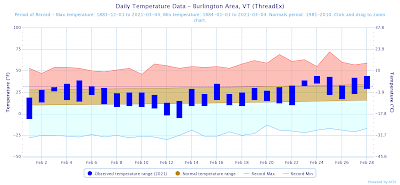
(NOAA Regional Climate Centers/xmACIS)

In the above temperature graph, you can see how maximum temperatures had several days where they did not reach the "red zone" of above normal temperatures. This helped contribute to the below normal average maximum temperature for the moth. Also, we had no ridiculous heat spells or cold snaps this moth, as shown by the temperatures failing to reach record levels.

February had 18 days where the maximum temperature was less than or equal to 32 °F, when the normal value is 15.6 days, and there were 27 days where the minimum temperature was below 32 °F, when the normal value is 25.9 days. Lastly, on three days the temperature dipped below 0 °F. In a normal February, we would have 5 of those days.

Overall, I'd call this February a fairly normal one at BTV temperature-wise. We had no ridiculous heat or cold, and temperatures were fairly average. We saw temperatures that ranged from -6 °F to 44 °F, which is only a 50 °F range.

Precipitation

We saw 1.55 inches of total precipitation this February, when the normal value is 1.76 inches, giving a departure from normal of -0.21 inches. As is typical in February, there were no days with extremely impressive precipitation accumulation - there was only one day which featured greater than 0.50 inches of precipitation. That occurred when we had 0.62 inches on the 16th.

Snowfall

As for snow, it was a snowier than normal month at BTV. We had a total of 23.7 inches of snow, when the normal value is 16.4 inches, giving a departure from normal of 7.3 inches.
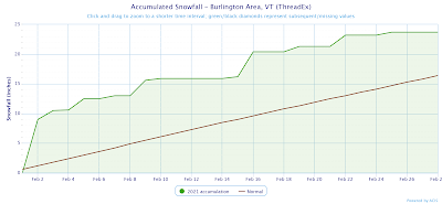
(NOAA Regional Climate Centers/xmACIS)

As you can see in the above chart, things got off to a quick start with significant snow at the beginning of the month, and they did not look back.

We had 6 days with snowfall greater than 1 inch, and the snow stuck around. The average snow depth for the month was 13 inches.

Wrap up

It was nice to see a more "normal" February at BTV and in Vermont this year after a slow start to winter. March is looking to trend a bit warmer, but we'll have to wait and see what the month has in store for us!

Wednesday, March 3, 2021

BDL Winter Recap

I previously examined winter 2020-2021's weather at Burlington International Airport. Now, let's take a look at what Bradley International Airport (BDL) in Windsor Locks, CT saw.

Temperatures

This winter's mean maximum temperature was 38.0 °F, while the mean minimum temperature was 22.8 °F, and the mean daily average temperature was 30.4 °F.

(NOAA Regional Climate Centers/xmACIS)

Like what we saw at BTV, the above time series graph clearly shows that the majority of temperatures were above normal this winter, and we only had a few cold spells where temperatures dipped into the "blue zone" on the above graph. One daily record high temperature was reached, when the temperature rose to 61 °F on December 13. 

With data dating back to the winter of 1905-1906, this winter ranks as the 35th warmest on record, when we look at mean daily temperature data. See the plot below to see how this winter stacked up compared to others.

(NOAA Regional Climate Centers/xmACIS)

Precipitation

BDL experienced slightly above normal precipitation this winter, with 11.08 inches of total precipitation falling when the normal value is 9.56 inches, meaning we had 116% of normal.

(NOAA Regional Climate Centers/xmACIS)

Precipitation was fairly consistent, gradually accumulating over the course of the winter.

Snowfall

Let's take a look at snow. BDL had 39.1 inches of snowfall, when the normal values 30.7, giving a departure from normal of 8.4 inches. In the following snowfall accumulation time-series, we can clearly see the influence of our two major winter storms, the one in December that produced over a foot of snow and the one to open February that produced another foot.

(NOAA Regional Climate Centers/xmACIS)

In addition to those days, there were a handful of other days that had moderate snowfall accumulations. 

How does the snowfall this winter stack up when compared to other years? Take a look at this plot to see that snowfall is increasing each winter, and this winter's snow fits the general trend.

(NOAA Regional Climate Centers/xmACIS)

While the start of spring may feel a bit wintry so far, we'll see what the rest of the season has in store.

Tuesday, March 2, 2021

A Look at this Morning's Weather

The arctic front has moved through, and it is simply brutal out there. Take a look at some current temperatures this morning:

(Utah MesoWest)

When you combine temperatures near zero and a brisk northwest wind, it will feel frigid out! Take a look at the Mount Washington observed weather this morning. At the summit, temperatures were -26.5 °F, and the wind speed average was 107.1 mph! Those are hurricane force winds, and they made for a wind chill of 80 below zero!

(Mount Washington Observatory)

Here in Vermont, Mt. Mansfield was reporting a temperature of -13 °F this morning. March is certainly entering like a lion in New England this year.


Monday, March 1, 2021

BTV Winter Recap

Although it may not feel like it with the arctic front moving through tonight, today is the first day of meteorological spring, and with that, I'd like to take a look at the winter we had at Burlington International Airport (BTV) in South Burlington, VT. Meteorological winter is defined as the period from December 1 to the end of February. 

Temperatures

The average maximum temperature this winter was 32.3 °F, while the average minimum was 18.4 °F and the mean average daily temperature was 25.4 °F.

(NOAA Regional Climate Centers/xmACIS)

In addition to nicely showing variability of the weather (we can clearly see some of the warmer and colder periods), we can clearly see that it was a hot winter. Two days, December 1 and 25, set temperature records for those days, and we never came close to setting a minimum temperature record. As a whole, the above image shows that few days were colder than normal, while many days were warmer than normal, with the blue bars extending into the "red zone" of above normal temperatures.

How do the temperatures this winter compare to other winters? With data extending back to the winter of 1884-1885, this winter was the 14th warmest on record at BTV, when we consider average temperature.

(NOAA Regional Climate Centers/xmACIS)

The above figure shows a clear warming trajectory in our winters at BTV.

Precipitation

This winter was drier than normal by 1.66 inches, largely due to the dry December that we had.

(NOAA Regional Climate Centers/xmACIS)

A more relevant metric for Vermont is accumulated snowfall, and this winter was just about normal.

(NOAA Regional Climate Centers/xmACIS)

In the above snowfall accumulation graph, we can see that winter started fairly slow at BTV snow-wise, but things really got going in January and February. In the end, BTV had 55.5 inches of snow, when the normal value is 54.4 inches.

If we only include data for January and February, the above plot looks quite different, as the January-February period this winter was about 10 inches snowier that normal (See below). So while January and February were fairly snowy, December saw little snowfall accumulation.

(NOAA Regional Climate Centers/xmACIS)

The following plot shows that winters at BTV are getting snowier. The regression line shown on the plot indicates that if trends were to follow, this winter would have seen 63.0 inches of snow. I find it interesting that in a warming climate, things are getting snowier.

(NOAA Regional Climate Centers/xmACIS)

As a whole, this winter was warmer than normal, but snowier than normal. Welcome to spring!