Sunday, February 28, 2021

Frigid Weather to Come

After what will be a mild day with fairly quiet weather today, Monday evening into Tuesday morning will bring some frigid temperatures, reminding us that even though spring will have begun, we are still susceptible to cold weather.

What will happen? Well, a few factors will contribute to this cold weather, despite the mild conditions that we'll experience to close out the weekend. First, a series of cold fronts will move through the region, as shown in the following NWS surface maps:

This morning (NWS)

Tomorrow morning (NWS)

These fronts will contribute to falling temperatures, some precipitation that could include snowfall if temperatures drop enough, and gusty winds. 

Following these cold fronts, a wavy jet stream will cause a part of the polar vortex to descend into our region on Monday night into Tuesday.

(Tropical Tidbits)

If we pick out a GFS sounding for Vermont for around midnight on Monday, we can see cold surface temperatures and a steep lapse rates which will contribute to gusty winds, compounding the effects of the cold temperatures.

(Tropical Tidbits)

What does this mean for conditions at the surface? I'd expect temperatures below zero for much of interior New England, and upper elevations in the mountains could reach -10 °F.

(Tropical Tidbits)

Combine the frigid surface temperatures with winds that could gust to 45 mph, and you're looking at wind chills that could reach -30 °F in spots! That certainly is cold.

(Pivotal Weather)


Friday, February 26, 2021

Friday Forecast

A nice, seasonable day is in store today, as high pressure builds in the region.

(NWS)

With that, expect abundant sunshine, temperatures rising into the 30s, and light winds.  Here's a photo of today's sunrise that I took this morning:


The NWS hourly forecast graphic forecast graphic for Middlebury, VT is looking quite nice, indicating clear skies, seasonable temperatures, and light winds.

(NWS Burlington)

That's all for today's quick forecast. Enjoy the spectacular late-winter day!

Tuesday, February 23, 2021

State of the Snowpack

Another round of snowfall impacted the region yesterday and a bit more is expected throughout the day today, bringing a solid snowpack to New England. That is set to change though, as a warming trend is forecast for the near to medium-range future.

(NWS/CPC)

Before we see some melting snow that we have not had much of this winter, lets take a look at where our snowpack sits now. 

Most locations have a snow depth greater than 5", which is a welcome sight compared to recent winters.

Feb 23, 2021 (NOAA/NOHRSC)

Compare the above current snow depth map to the one from the same date in 2020, and you'll see a stark contrast in what areas have snow on the ground. 

Feb 23, 2020 (NOAA/NOHRSC)

Comparing those two maps we can make some interesting observations. More northern locations, like northern VT, NH, interior Main, and Quebec had a deeper snow depth on this date last year than they do now. On the flip side, areas in southern New England, New York, and New Jersey, which had virtually no snow on this date last year, have a decent snowpack now. I think this observation speaks to the fact that we had more borderline rain/snow events last year than we have had this year. Those events tend to favor northern areas, when southern locations could see all rain.

To focus on a specific location that I often like to look at, lets take a look at the Mt. Mansfield Snow Stake:

(NWS/Matthew Parrilla)

The summit of the mountain currently has a snow depth of 48", below the normal amount of 62".

One last thing I'd like to point out is the snowpack at Burlington International Airport. There, the current snow depth is 14 inches, which is nothing too anomalous for this time of the year in Vermont. However, there has been at least a foot of snow on the ground for the past 20 days. Since 1990, there have only been two years with at least one foot of snow on the ground for 20 or more days (the other was 2007).

We'll start a warming trend soon, the sun angle will start to increase, and we're approaching spring and a climatologically warmer period, so enjoy the snow while we have it! 


Saturday, February 20, 2021

My Time in Colorado

Vail on a surprise powder day

I spent my last 5 weeks in Colorado and had an absolute blast - it was an experience that I'll remember for the rest of my life. Seven of my college friends and I were based in the Eagle County area, home to multiple world class ski areas. While our college was remote, we figured it would be a perfect time to explore a new place. It was interesting to see a more continental weather pattern and be exposed to different weather for an extended period of time. Here are I few observations I have about the weather in CO over the past 5 weeks:

  • The snowpack/snowfall was especially thin during the early parts of my time there. Snowfall was roughly 70% of normal along the I-70 corridor for much of January, though southern areas (like Wolf Creek) were doing a bit better.
  • It never rains in CO during the winter. Growing up in CT, I became used to freeze/thaw cycles and plenty of rain during the winter. Throughout my time in CO, I didn't see a drop of rain.
  • I was a bit surprised by the amount of cloudy days with no snow that we had. Many western resort towns tout their high number of days of sunshine annually, but we did have plenty of grey, cloudy days with flat light. This surprised me a bit.
  • Storms in the Colorado mountains come in multiple bouts. A few times during my stay in CO, the storm track would favor the Colorado rockies. While daily snowfall totals were never so impressive, (the largest single day total was 15"-see photo below) over the course of 4 days, we could see light to moderate accumulations of 1-5". That, coupled with cold temperatures allows Colorado to build its hefty snowpack which is vital for much of the state.

A Beaver Creek powder day

Here are some additional reflections on my time in the west:

A morning skin at Beaver Creek


  • The ski experience was definitely different this year, but it felt pretty safe. Lift lines were spaced and spacing on the individual chairs was required. Resorts set up a reservation system and limited capacity for each day. Of course, masks were worn at all times. Being an outdoor activity and with resorts imposing additional restrictions/precautions, skiing felt pretty safe to me.
  • I had a blast talking to locals, and almost all of them made their moved to the mountains at some point in their lives. They were extremely friendly to me.
  • It was great to live with a group of my college buddies for the month. We cooked, cleaned, had lots of fun together, and most importantly, we remained safe.
  • I hoped to get my first taste of western backcountry skiing, but that was not meant to be this year. A weak, unstable snowpack, combined with my limited experience and knowledge required for entry to the backcountry made it the safer call to stick to the resort. I did get really into skinning, though, especially for sunset and sunrise, which are peaceful times to be on the mountain.
Sunset at Beaver Creek

And now, here are some numbers from the trip:

  • 3 - different resorts skied. These were Beaver Creek, Breckenridge, and Vail
  • 33 - days skied. I skied just about every day, except for the weekend when we traveled to southern Utah.
  • 459 - lifts ridden (that's according to the Epic Mix app - who knows how accurate that is).
  • 803,929 - vertical feet skied (again, according to the Epic Mix app)
  • 1 - trip of a lifetime.
Hot springs near Glenwood Springs, CO

I'm lucky to have been able to spend my last Middlebury College winter term exploring in the mountains of CO. This was certainly an experience I'll remember for the rest of my life.

Wednesday, February 17, 2021

End-of-week snowstorm

After what has already been a busy weather-week in the Northeast, we will have another snowstorm late this week. Differing from the snow/mix/rain event we had earlier in the week, this one looks to be an all snow event, except for maybe locations along the coast. This storm is especially of interest to me, because I will be traveling from Colorado to Connecticut tomorrow. Here are some details:

Timing

This will be a long duration snow event, extending from Thursday afternoon into very early Saturday. Snowfall rates look mostly light to moderate though, meaning that travel should not be too impacted.

The NAM shows the onset of snow on Thursday morning in CT, beginning at southern locations and gradually progressing northward.

NAM Thursday AM (Tropical Tidbits)

Here's what the NWS thinks for snow onset time:

(NWS Boston)

And on early Saturday morning (around midnight), the NAM is still indicating the potential for some lingering snow showers.

(Tropical Tidbits)

Accumulations

Snowfall seems to be mostly in the 6-10 inch range, with some areas in the northwest hills of Connecticut or the Berkshires of Massachusetts maybe doing a bit better. Here's what the National Weather Service in Boston is thinking:

(NWS Boston)

Impacts

As I previously mentioned, most of the snow will be fairly light (or moderate at times).  So while there will be significant snowfall accumulations from this storm, it will pile up over about a 36 hour period. This will make travel more possible, though when traveling in snow, it is always important to be cautious. I suspect that many schools will be cancelled or conduct remote learning on Friday. Thursday will be a tough call for superintendents, though I expect many to play it safe and call for an early dismissal.

Enjoy the new snow!

Monday, February 15, 2021

Historic Weather Event Underway

It's rare that I look at weather events outside of the New England on this blog, but what is happening in southern parts of the country is truly remarkable and worth taking a deeper look at.

Temperatures

First, take a look at current air temperatures this morning.

(Mesonet)

Yes, you're seeing temperatures ten below zero in Texas this morning! And temperatures approaching 40 °F below 0 is dangerously cold. To understand how remarkable this arctic blast is, take a look at all the stations that have broken all-time or February low temperature records so far:
(Coolwx)

And to understand what these temperatures mean compared to normal, take a look at the current 2-m temperature anomaly analysis from the GFS:

(Tropical Tidbits)

It looks like temperatures in spots are approaching 30 °F below normal, and almost breaking the map's colorbar!

Snowfall

What's especially fascinating to me is the snow that has fallen for virtually all of Texas. Here is a NWS snowfall report map for the past 48 hours, showing accumulating snowfall in Houston, Dallas, and San Antonio!

(NWS)

Impacts

Many locations that are experiencing this bast of arctic air and unusual snowfall are simply unprepared to deal with it. Here is a look at I-10 in San Antonio, showing a snow-covered road with no cars.

(WeatherBug)

Travel will be impacted for days in some areas. To compound things, frozen wind turbines have impacted Texas' electrical grid, and increased demand has caused blackouts.

This is a once-in-a-lifetime event, and we can only hope for safety for all.

Saturday, February 13, 2021

Mixed Monday-Tuesday Storm

Our next storm is looking like a mixed-bag, with areas north seeing a solid snowfall and southerly areas seeing some mixing and rain.

Earlier on, the storm was looking more wintery, but the last few GFS runs have brought the low pressure center further north, as shown in this trend GIF below.

GFS (Tropical Tidbits)

The NAM seems to agree, showing an even warmer setup in areas further south. See the whole trajectory of the storm from the most recent NAM run:

NAM (Tropical Tidbits)

That model has the low pressure center tracking even further north, with parts of Northern New England still seeing snow, while the south experiences some mixing and rain. The yellows in the above GIFs indicate some heavy rainfall that is set to hit southern parts the region. With a solid snowpack in place for areas south, I suspect that the warm temperatures and rain will cause some significant snowmelt and even some flooding.

With snow beginning on Monday night and extending through Tuesday, northern areas will look to increase their already deep snowpack. Here is a NAM 10:1 snow-to-liquid ratio map for now through Tuesday at midnight. 

(Tropical Tidbits)

I think that these snowfall totals are a tad overdone for areas south, while northern locations that can expect a more powdery snow can see even more snow than the above map shows. This will add to an already deep snowpack that the Northeast currently has.

(NWS Burlington)

Enjoy the next dose of winter weather!

Friday, February 12, 2021

Arctic Air

The big weather story for much of the country this weekend is the impressive arctic air outbreak that many will experience.

Here's a look at current surface temperatures across the U.S.

(Weather Central)

Many areas in the midwest are currently seeing temperatures below zero, and this is just the beginning. Notice how parts of Texas are also well below freezing.

Take a look at the most recent operational GFS 2-m temperature forecast from now through next Friday. That persistent, stubborn arctic airmass will not release its wrath on much of the country.

(Tropical Tidbits)

What is responsible for this arctic blast that we'll be experiencing? We can thank the polar vortex, a strong and persistent area of low pressure and cold air that typically lies in the arctic. When the polar vortex weakens (as is the case now), bouts of arctic air can push southward, causing frigid temperatures here in the U.S.

(NOAA)

To visualize what we're experiencing now, let's take a look at the GFS 2-m forecasted temperature anomaly map for North America on Monday.

(Tropical Tidbits)

Notice how much of the U.S. will be much colder than normal, while the arctic will be warmer than normal. This is due to the weakening polar vortex. The weakening of the polar vortex will allow cold air to descend from the arctic, leaving warmer-than-normal air there, while areas south will experience frigid arctic air.

Just for fun, here's a 2-m temperature map for Tuesday morning from the GFS. Much of Texas will look to experience below zero temperatures.

(Tropical Tidbits)

Pray for Texas!

Monday, February 8, 2021

BDL January Recap

Here is my recap of the January 2021 weather for CT focusing on Bradley International Airport (BDL). The month started fairly benign, though winter turned on for the end.

Temperatures

Consistent with what we saw for much of 2020, temperatures were warmer than normal this January. The month's mean daily temperature at BDL was 29.0 °F, when the January normal value is 26.1 °F, giving a departure from normal of 2.1 °F. Minimum temperatures were on the higher side, as the minimum temperature departure from normal was 3.6 °F and the maximum temperature departure from normal was 2.1 °F.

(NOAA Regional Climate Centers/xmACIS)

In the above chart, you can see the warm trend for the start of January at BDL, and it is clear how much things cooled for the end of the month. In fact, only a few days had low temperatures below normal, which you can see at the end of the month on the right hand side of the chart.

A typical January would have 2.4 days where the temperature would drop below 0 °F; this January, we had none.

Precipitation

We had 2.43 inches of total precipitation at BDL this January, when the normal value is 3.23 inches, giving a departure from normal of -0.80 inches.


(NOAA Regional Climate Centers/xmACIS)

The brunt of the precipitation came from a rainstorm on January 16, when we saw 1.62 inches. On most days, though, conditions were fairly dry.

Snowfall

It was an unfortunate January if you like snow, as BDL only saw 5.0 inches of snow, with a 0.5 inch liquid equivalent. 15 days saw at least a trace of snow, though virtually none of those days amounted to any snowfall accumulation. Our largest snowfall accumulation came on the 26th and into the 27th, when BDL recorded a total of 2.8 inches of snow.

While January was not too wintery at BDL, February should change that trajectory when the month wraps up.

Sunday, February 7, 2021

Super Bowl Snow

Expect a quick-moving snowstorm to impact the eastern seaboard today, bringing moderate snowfall accumulations to many population centers.

(Pivotal Weather)

Here's a look at today's forecast map from the National Weather Service.

(NWS)

That low that you see located near North Carolina will be our weather-maker today, and it's a quick-moving one, as it will track out to the coast of Maine by 10:00 p.m. tonight, as shown in this GIF of the NAM model.

NAM GIF through hour 14 (Tropical Tidbits)

I think this will be a mostly snow event, though some areas could see some rain at the storm's onset. Speaking of the onset, it will be a struggle for the storm to get going, as there is a lot of dry air in the lower atmosphere that we need to overcome. Here's a look at the current HRRR model sounding for western CT:

(Tropical Tidbits)

The dew point at the surface and up to 800 mb is quite low, so any precipitation in the upper atmosphere that is forming at the moment is likely evaporating before reaching the surface, something called virga. A current radar image shows snow, though I suspect many are not yet seeing flakes.

(Penn State E-wall)

As for snowfall totals, expect moderate amounts, with coastal areas favored:

(Pivotal Weather)

Enjoy the quick-hitting storm, and enjoy the Super Bowl!

Friday, February 5, 2021

BTV January Recap

I'm a bit late to this one, but as I like to do at the end of each month, here's my recap of this January's weather in Vermont, focussing on data from Burlington International Airport (BTV).

Temperatures

Though it may not feel like it after your experiences at the very end of the month, mean daily temperatures in January 2021 were 4.3 °F above normal. Our mean temperature was 23.0 °F, when the normal value is 18.7 °F.
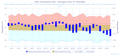
(NOAA Regional Climate Centers / xmACIS)

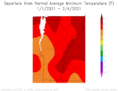
In the above chart, you can clearly see how the January started on the warmer side, and stayed that way for pretty much the entire month until the last few days. Temperatures were not anomalously warm; rather, they were slightly above normal each day, and did not cool much, causing a large temperature departure from normal for the month. Interestingly, the average maximum daily temperature was only 1.8 °F above normal (27.3 °F), which pales in comparison to the 6.7 °F above normal for the minimum daily temperature.
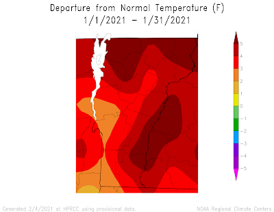
(NOAA / High Plains Regional Climate Center)


Even with the inclusion of data from the first few days of February, notice how much warmer than normal the minimum temperatures have been to start the year.
(NOAA / High Plains Regional Climate Center)

Our monthly maximum temperature was 39 °F, which we hit on the 15th and 16th, while the month's low temperature was reached on the 31st, at -7 °F.  In a normal year, there would be 8 days where the temperature drops below 0; this year, there were only 2.

Precipitation

It was a fairly typical month for precipitation, with 1.72 inches of total precipitation, compared to the normal 2.06 inches. The largest storm was on the 16th, when we saw 0.71 inches of precipitation that included some snow.
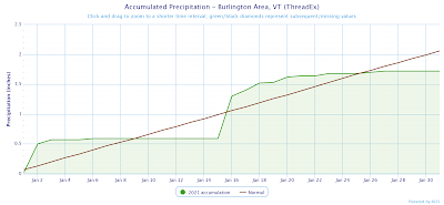
(NOAA Regional Climate Centers / xmACIS)

Snowfall

Lastly, BTV had a slightly snowier-than-normal January. With 23.6 inches of snow falling (compared to the normal 21.1 inches), the departure from normal was 2.5 in. The largest daily snowfall occurred on the 2nd, with 6.0 inches falling. Other than that, there were many days with slight accumulations of snow, as is typical of the Champlain Valley in January. In fact, there was at least a trace of snow at BTV on all but 6 days during the month.


Overall, it was a warm and dry month. Look for a much cooler trend for the start of February!

Wednesday, February 3, 2021

Storm Recap

Things have settled and the historic snowstorm has ended.

The storm was well forecast, beginning on Sunday evening, and gradually tapering off by Tuesday morning. Snowfall rates were impressive, with up to 2 inches per hour falling at times as the heaviest bands formed. Here's a look at snowfall totals from the NWS Eastern Region.

Parts of northern New Jersey and western Pennsylvania were the big winners, with Nazareth, PA seeing 36.1 in. and Mount Arlington NJ seeing 35.5 in.

Straying from what has become the norm over the past few years, much of the Northeast now has a solid snowpack, and it'll look to stick around. Seasonably cold temperatures are in the forecast for the next few days.


(NOAA/NOHRSC)

At the Mt. Mansfield snow stake, where I like to track snow depth, we're still playing catch-up, though things are trending in the right direction. The current snow depth at the stake is 41 in. when average is 53 in.

Feb 3 Mt. Mansfield Snow Depth (SkiVt-L)

This was a long duration storm that impacted virtually all locations in the Northeast. It'll be interesting to see how things trend as we continue through the rest of winter.