 |
| (NWS) |
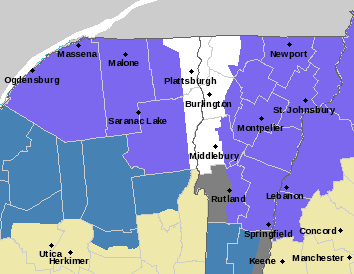
A winter weather advisory has been issued for much of northern Vermont and New Hampshire and New York, with winter storm watches in place in other areas. If you live in northern areas at elevation, expect to wake up to some snowfall tomorrow that will likely remain snow all day. This is a warmer event, so areas in the valleys will likely see a changeover to rain mid-day (see sounding for Champlain Valley below).
 |
| (Tropical Tidbits) |
Due to the warmer nature of this storm, snow-to-liquid ratios will be low, causing a heavy, wet snowfall that is climatologically uncharacteristic of mid-January. For ski areas, this will be helpful to build up a base that is still fairly thin.
The elevation-dependence makes snowfall totals difficult to predict. Here's what the National Weather Service is thinking.
 |
| (NWS Burlington) |
Precipitation leaves the region by late-Saturday, though we may see some lingering snow-showers in the mountains into Sunday.
Enjoy the weekend!
No comments:
Post a Comment