Sunday, January 31, 2021

Major Snowstorm Ahead

I'm a bit late to getting this post out as I've been busy today. As I'm sure you've heard by now, a major snowstorm is set to impact the Northeast. Winter storm warnings have been issued for much of the Northeast, from West Virginia through Maine.

(Pivotal Weather)

Here are the details:

Timing

As of 8:00 p.m., light snow is underway in New Jersey, Southern New York and some of Connecticut. The main event arrives tomorrow morning, continuing throughout the day tomorrow and lingering into Tuesday morning and mid-day.

(NWS Boston)

Here is a nice visualization from the NWS Eastern Region, showing the timing and nature of the storm.

A look at the expected timing and evolution of the precipitation from the winter storm that will be impacting the Eastern US during the next 3 days. pic.twitter.com/QSriEny6Up
— NWS Eastern Region (@NWSEastern) January 31, 2021

The following GIF, which shows the NAM, demonstrates snow beginning now and continuing through Tuesday with some lingering showers on Wednesday as well.
 
(Tropical Tidbits)

Impacts

Snow totals will be largest in Northern New Jersey, Southern New York, and parts of southeast Connecticut. The exact locations of the largest totals will be dependent on where heavy snow bands set up. Expect double digit snowfall totals for much of the region - here's what the NWS NDFD snowfall forecast shows:

(Pivotal Weather)

Winds will be gusty for this storm, causing potential power outages. And of course, with snowfall rates this large, travel will be treacherous at times. The governor of Connecticut has instituted a travel ban on tractor trailers on major interstates.

This snowstorm will impact the entire region, with the main target being further south. On the heals of this storm, cold temperatures will persist, allowing the snow to stick around and creating a wintery seen for a few days!

Friday, January 29, 2021

Colorado Update

I haven't posted quite as frequently as I'd like, but I've been spending as much time outside as possible and enjoying my time in Colorado to the fullest.

Locals say that the region's snowpack is quite thin this year (about 70% of normal) and ski conditions are some of the worst in years, but coming from the east, it's quite good! 

(USDA)

We've seen many days with minor snow accumulations, but no big storms. That makes for fun groomers to ski with some powder stashes that we can find.

My friends and I are based at Beaver Creek, so we've had plenty of fun days there with lots of cruisers and sunshine! I've gotten into skinning at the resort this year, and have been treated to some spectacular sunrises and sunsets while skinning.


I was hoping to venture into the backcountry while here, but with an unstable snowpack, minimal avalanche training, and no true backcountry experience, I think I'll save that for a future year.

In addition to skiing at Beaver Creek, I've had super days at Vail and Breckenridge. Some of the higher elevation terrain at Breckenridge was unlike anything I'd skied in my life!


This weekend, we traveled to Moab in southern Utah to visit Arches and Canyonlands National Parks. The drive was absolutely spectacular, and we stopped at Fisher Towers on the way. 


We spent the entire day today in Arches National Park, and visiting the iconic Delicate Arch was the highlight of the day. During the busy season, as I was told, 100s of people crowd around the arch and wait in line to take a photo. With only about 10 people there when we arrived in the late afternoon, it was quite serene - and of course, the scenery was spectacular.


I'm excited to visit Canyonlands National Park tomorrow before returning to Colorado for some more fun in the snow!

Saturday, January 23, 2021

Cold and windy tonight

Some of the coldest air of the season is on the way for tonight, leading the National Weather Service to issue a Wind Chill Advisory for parts of Northern New York and Vermont.


(NWS Burlington)

Temperatures at the surface will range from -10 °F to 10 °F depending on location, with higher elevation zones on the colder end.

(Tropical Tidbits)

Those chilly temperatures combined with moderate northwesterly winds will create wind chills below -20 °F in spots. 

(Tropical Tidbits)

Here's a sense of what to expect in Burlington tonight each hour:

(NWS Burlington)

This cold and wind will feel like some of the chilliest weather of the season so far. Burlington, VT, has still not recorded a temperature below 0 °F, and while I don't think the temperature will drop below zero tonight, the wind should certainly make it feel below zero.

Expect the cold air to persist into early next week, before temperatures moderate to seasonable levels by mid-week.

Thursday, January 21, 2021

Northeast Snowpack Update

After the storm last weekend and some additional mountain enhanced snowfall, our snowpack in New England looks much different from how it did one week ago.

To start, let's look at the Mt. Mansfield snow stake, located at the summit of Vermont's highest peak. The current snow depth is 36 inches, when the normal value for January 21 is 45 inches, so the snow depth still sits below normal.
Mt. Mansfield Snow Depth (SkiVt-L)

Though the Mt. Mansfield snow depth still lies below normal, as shown on the above graph, we have flattened the curve in the right direction - the vertical one.

Here's a map of the New England snow depth today:

(NOAA/NOHRSC)

The above image clearly reflects the latitude-dependent and elevation-dependent nature of our last storm. While mountainous areas have a more hefty snowpack, areas at low elevation hardly have any snow on the ground (see southern VT, where this is especially apparent).

The above map looks much different from how it did just one week ago:

(NOAA/NOHRSC)

While mountainous areas in Northern New England have seen a fairly snowy January, that has not been the case further to the south. Boston, for example, has only seen 0.2 inches of snow this month.

And as shown in the following image, the snowpack is fairly cold, and with cold temperatures continuing for the foreseeable future, the snow will stick around!

(NOAA/NOHRSC)

Sunday, January 17, 2021

Storm Recap

This storm was a bit of an over performer, bringing close over 20 inches of snow to parts of Vermont, with upslope flow and additional moisture set to provide additional snow showers to the northern mountains for the rest of the day.

Take a look at snowfall totals from the storm:

As you can see in the map (and as was well-forecasted), the snow was very elevation-dependent, with areas in the valleys seeing close to no snow while mountainous regions saw close to two feet.

The snow provided a much-needed boost for ski areas, and here are what some are reporting for the past 24 hours:

Stratton - 18"

Sugarbush - 15"

Bolton Valley - 10"

On the back end of this storm cold air will filter in, preserving the snow pack that has now built up in northern New England. This GIF shows surface temperatures from the GFS from Monday through Thursday night. It will be chilly!

(Tropical Tidbits)

It's tough for me to write about all the snow that the East has received, especially after coming out to Colorado, where I'll be for the next few weeks doing remote school. The mountains here are absolutely gorgeous, and it's fun to be able to do lots of skiing, but I'm ready for a true western cold-smoke powder day. Here is a photo from my skin up Beaver Creek this morning:


Stunning scenery and a nice sunrise, though I do think those trees would look better with a coat of white on them - hopefully the East can share some snow!

Friday, January 15, 2021

Storm Update

The picture for this weekend's storm is beginning to become more clear, and it's looking like a very latitude and elevation dependent one.

(NWS)

A winter weather advisory has been issued for much of northern Vermont and New Hampshire and New York, with winter storm watches in place in other areas. If you live in northern areas at elevation, expect to wake up to some snowfall tomorrow that will likely remain snow all day. This is a warmer event, so areas in the valleys will likely see a changeover to rain mid-day (see sounding for Champlain Valley below).

(Tropical Tidbits)

Due to the warmer nature of this storm, snow-to-liquid ratios will be low, causing a heavy, wet snowfall that is climatologically uncharacteristic of mid-January. For ski areas, this will be helpful to build up a base that is still fairly thin.

The elevation-dependence makes snowfall totals difficult to predict. Here's what the National Weather Service is thinking.

(NWS Burlington)

Precipitation leaves the region by late-Saturday, though we may see some lingering snow-showers in the mountains into Sunday.

Enjoy the weekend!


Wednesday, January 13, 2021

Weekend storm

I haven't posted in the pat few days because there simply hasn't been much to talk about weather-wise in New England.

Yesterday's NWS forecast chart (NWS)

As shown in yesterday's National Weather Service forecast map, high pressure dominated for much of the country. The weather remains quiet until the weekend, as a cold front and low pressure system will bring some rain to southern New England with some mixing and snow to interior, mountainous areas.

Saturday Forecast Map (NWS)

There will be considerable moisture in the atmosphere, which will bring significant precipitation to some areas.

The storm track is still uncertain this far out and will become more clear as we approach the weekend. The GFS has the low tracking further to the east than most other models I have seen. If this track verifies, we could see less rainfall, and the mountains might not pick up too much snow.

Sat-Mon GFS (Tropical Tidbits)

For southern New England, this storm is looking like an all-rain event, as temperatures will simply be too warm to support any mixing.

(Tropical Tidbits)

In northern VT, NH, and western ME, however, there will be enough cold air to support accumulating snowfall.

While the details of this storm are still somewhat unclear, it's nice to have some more active weather to look at.

Saturday, January 9, 2021

Winter Report Card So Far

To put it simply, the weather over the next week will be quite boring. There are signs that changes will be coming in the medium to long term due to a phenomenon called a sudden stratospheric warming (SSW), but over the next week or so, will see fairly seasonable weather with sunny skies.

With not much to talk about in the immediate future, I figured I'd give a winter report card through today (Jan 9).

Walking outside to get the newspaper at my house in CT this morning, the scene does not look very wintery.


Much of New England has a moderate snow depth, but nothing too significant, with maximum depths no greater than about 15 inches.

(NOAA/ Northeast River Forecast Center)


(NWS Burlington)

The Mount Mansfield snow stake currently has a snow depth of 15 inches, well below its January 9 normal value of approximately 40 inches.
Mount Mansfield snow depth time series (SkiVt-L/UVM)


But statistically, how has winter been in New England so far? Using data from various NWS forecast offices throughout the northeast, I put together this table, showing snowfall since December 1 for different sites in New England.

Seasonal snowfall through Jan 9 (Data from NWS)

These are major cities in New England, and we can see that the big winner so far is Concord, NH, which has seen 14.3 more inches of snow than normal this year. That is largely due to the major storm on December 17, which southern New Hampshire did very well in. Areas further north, like Burlington, VT or Bangor, ME, have struggled so far this year, seeing less than their normal snowfall.

To see how ski resorts are doing for snowfall, I recommend the site bestsnow.net.

As for temperatures, it's been a fairly warm winter in New England. The following image shows the percentiles for mean temperatures from Dec 1 through Jan 1. BTV's winter is in the 96th percentile, meaning it's having one of the warmest winters to date on record. 

(Southeast Regional Climate Center)

We can see that the further north in New England you go, the warmer it has been relative to normal.

To sum, I'd call this winter a fairly average or slightly below average one in New England so far. While it's unfortunate to see the ground bare on January 9, we have seen one major nor'easter and no extreme warm spells. For many areas, snow-to-date is above normal, though northerly areas that are accustomed to abundant snow have seen less than normal snowfall. Over the next few days, look for no chances for new snow but seasonal temperatures.

If you are looking for snow, Spain is one place to look. Here is a video that my host family from my semester abroad in Madrid sent me. Madrid, where snowfall is a rarity, is seeing its largest winter storm in 50 years.

Tuesday, January 5, 2021

BDL December Recap

Just like I've previously done for Burlington International Airport (BTV), here is my recap of this past December's weather at Bradley International Airport (BDL) in Windsor Locks, CT - close to where I was for all of the month.

Temperatures

The mean daily average temperature for the month at BDL was 33.7 °F, warmer than the normal value of 31.6 °F by 2.1 °F. The month's average maximum and minimum temperatures were 42.2 °F and 25.3 °F, respectively - both are values roughly 2 °F above normal.

The temperature graph below shows the slightly warmer-than-normal temperature trend for BDL this December, with the only true cold spell occurring after our major winter storm on Dec 17, and a few warm periods at the start of the month, the middle of the month, and on Christmas day, when the temperature reached 63 °F.

(NOAA Regional Climate Centers/xmACIS)

The Hartford area set one record high temperature this December, when we reached 61 °F on December 13, surpassing the previous Dec 13 record of 60 °F set in 1946.

The month's low of 1 °F was reached on December 19.

Precipitation

Straying from the trend of dry weather that BDL grew accustomed to over 2020, December 2020 was a wetter-than-normal month. A total of 5.30 inches of precipitation fell, which surpasses the normal monthly value of 3.44 in. by 1.86 inches.

(NOAA Regional Climate Centers/xmACIS)

As shown in the above precipitation chart, much of our precipitation fell in 3 separate events events: a small snowstorm with heavy, wet snow and some rain on December 5, our major snowstorm on December 16-17, and the large rain event on Christmas Day. On December 25, the Hartford area saw 2.12 inches of rain, breaking the old Dec 25 record of 1.39 inches set in 1979.

Snowfall

BDL had 13.3 inches of snow in December 2020, when a normal December would have 7.4 inches. There where seven days when at least a trace of snow fell. The bulk the snow fell during the Dec 16-17 storm,  when BDL received 12.3 inches over the course of those two days. The 7.8 inches of snow that fell on the 17th set a record for that date, breaking the previous record of 6.5 inches set in 2016.


While the warm 2020 trend continued at BDL, it was nice to see a wetter month with one major nor'easter. Let's hope for more major snowfalls in 2021!

Sunday, January 3, 2021

BTV December Recap

As I like to do at the end of each month, here is my recap of the weather at Burlington International Airport (BTV) in South Burlington, VT for December 2020. In a future post, I'll take a look at Bradley International Airport's December weather.

Temperatures

We started the month on a warm note, with the temperature reaching 66 °F at BTV on December 1. While setting a Dec 1 record, that temperature reading fell 2 degrees shy of the record December high temperature at BTV, which is 68 °F set in 2015. 

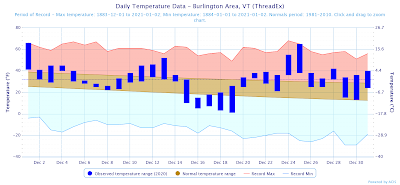
As a whole, December was a warm month at BTV. The mean monthly temperature was 31.3 °F, when the normal value is 25.8 °F, giving a mean temperature departure from normal of 5.5 °F for the month. We only had 8 days where the maximum temperature was less than or equal to 32 °F, and in an "average" month, we would have seen 13.3 of those days. Also of note, there were no days when the temperature dropped below 0 this December.

This temperature graph gives a good sense of the warm temperatures that BTV experienced this year, with an especially warm period around the start of the month and around Christmas day. In fact, BTV set a record high Christmas day temperature of 65 °F, surpassing the previous record of 62 °F set in 1964.
(NOAA Regional Climate Centers/xmACIS)

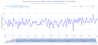
December 2020 was the 9th warmest December on record, falling far behind December 2015, which had a mean temperature of 39.2 °F.
Burlington Area mean Dec temperatures since 1900 (NOAA Regional Climate Centers/xmACIS)

Precipitation

It was a drier than normal month for the Burlington area, with 1.27 inches of total precipitation falling, when the normal value is 2.38 in. 

(NOAA Regional Climate Centers/xmACIS)

Christmas Day was the wettest day of the month, with 0.40 in. of rain falling.

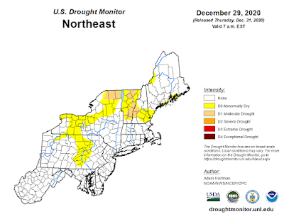
While much of the Northeast is no longer experiencing drought conditions, abnormally dry conditions persist at BTV.
(National Drought Mitigation Center)

Snowfall

BTV saw 8.2 inches of snow this December, when a formal December would have 17.9 inches, giving a departure from normal of -9.7 inches.

The greatest snowfall at BTV was on December 17th, when a large Nor'easter pummeled parts of Vermont with over 40 inches of snow. Burlington was a bit too far north to get in on the action, though the airport did record 2.5 inches of snow that day.


Overall, the last month of 2020 was an uneventful one at BTV, characterized by warmth and a few extremely warm days that set records. BTV has seen less than 50% of its normal snowfall at this point in the season, so lets hope that changes as we move into the new year.

Friday, January 1, 2021

Where things stand with climate

While the calendar has flipped and many are rejoicing that 2020 is behind us, the climate system knows nothing about the Gregorian calendar, and our climate is still in a dire state.

Atmospheric Carbon Dioxide

Despite a global shut-down mid-year, the monthly averaged carbon dioxide level at NOAA's Mauna Loa Observatory still reached its highest level ever, at 417.07 ppm in May. NOAA data also de-seasonalize carbon dioxide values (they tend to be highest in summer), and November 2020 (the most recent month with available data) had the highest de-seasonalized value ever, at 414.90 ppm. Observations of carbon dioxide at the observatory have steadily climbed since they began in 1958.


Carbon dioxide abundance in ppm over time at Mauna Loa Observatory (NOAA)

Arctic Sea Ice

The Arctic sea ice extent this year was much lower than the 1981-2010 median, and at times, it was the lowest ever.
(National Snow and Ice Data Center)

The blue line in the above graph shows 2020 Arctic sea ice extent through December 1. When we compare to the 1981 to 2010 climate normals (the grey median line in the above graph), 2020 and the past several years have had much lower sea ice extent than normal. The new climate normals for 1991 to 2020 will be released at some point soon, and it appears that the new median line and the interquartile range will be much lower than where it currently is.

To further show this pattern, here is a graph of sea ice anomalies in the Northern Hemisphere over time in January:
(National Snow and Ice Data Center)

The National Snow and Ice Data Center has lots more interesting data for other months and good visualizations, so I recommend looking at the center's website.

Temperature

For many spots in the world, 2020 was the warmest year on record. I like looking at NOAA's Global Climate Reports, which are released monthly. December's report has not yet been released, but the November report paints a clear picture that 2020 was an extremely warm year. According to the report, the Jan-Nov 2020 global temperature was 1.80 °F above average, which is the second warmest Jan-Nov period after 2016.

(NOAA)

Globally, it was certainly a warm year, but what happened locally?
In Burlington, VT, it was the second warmest year on record after 2012, and we had the most days with high temperatures above 90 °F since 1988 and the fewest days with low temperatures below 32 °F since 1941, as shown in the NWS tweet above. You could pick many sites throughout the northeast and U.S., and similar trends would arise:

(NOAA/HPRCC)

Lastly, as I previously mentioned, new climate normals for the period from 1991-2020 will be released at some point in this year. 
Climatologist Brian Brettschneider has done some really neat work to show how the climate normals will change from what they were. In virtually every site in the world, the new climate normals will be warmer than they were for 1981-2010 and the trend is especially pronounced in Europe.

I apologize for painting a grim picture of where things stand with climate, but its what the data show. Hopefully 2021 will usher in a renewed focus on tackling climate change.