Monday, June 29, 2020

Weekend Recap

Wow! We certainly had some exciting weather this past weekend, and we picked up some much needed rain. I'll unpack it all in this post.

To begin, we'll take a look at rainfall, which was much needed after we had been in a prolonged dry spell.
48 hour rainfall accumulation (NWS)
Take a good look at the above map (by clicking on it) to get a sense for how much rain fell over the weekend. One place that stands out to me is just southwest of Boston, where heavy rain was falling all afternoon. Additionally, the spot where you see 3.63 in. labeled is just near my home in Middlebury, CT, where we saw some nice downpoors yesterday afternoon. While almost everywhere in New England saw some form of precipitation, it is interesting to note how isolated the storms over the weekend were. You can clearly see where strong areas of convection set up on the above map.

Yesterday's storms were the more intense ones of the weekend, with heavy rumbles of thunder and lightning associated with them. My house briefly lost power, and I saw many reports of flooding. I was following the storms on radar using the app RadarScope (which I highly recommend downloading for use on severe weather days), and I saw some spots near Boston that got 1.5" hail. 

Interestingly, the storms yesterday were fairly slow moving, which caused the flooding that occurred in spots, as it was possible to receive up to 2.5 inches of rain in less than an hour. See the link below for a cool tweet showing satellite imagery of the storms yesterday.


In this GIF, you can clearly see how slow the storms were.

Despite the rainfall over the weekend, we're still well below average percipitation-wise this month at Bradley International Airport (BDL) in Windsor Locks, CT. According to the NWS climate data, BDL has seen only 0.82 inches of rain this month, which is 3.3 inches below normal.
BDL June 2020 climate data (NWS)
With only two days left in the month and some chances to accumulate precipitation each day, it'll be interesting to see how much closer to average we can get!

Saturday, June 27, 2020

Tricky Saturday Forecast

Happy Saturday!

It is early as I write, and the sun is shining and temperatures are quite pleasant. Temperatures and dew points dipped in the later parts of the week, making for a nice close to what began as a hot and humid week. Here's a photo of last night's sunset over Lake Quassapaug in Middlebury, CT, where my family and I had a nice picnic for dinner.
Sunset over Lake Quassapaug last night

I mentioned in my last post on June 25 (link here) that we were in need of some rain here in New England and that Saturday would be the best chance for some new precipitation. I still think that we will see some rain today, though it's a tricky forecast (as storms in the summer tend to be). The NWS Storm Prediction Center's (SPC) convective outlook for today places parts of Southern New England in a slight risk for severe thunderstorms.
Day one convective outlook (NWS)
Any convective storms that do form could contain damaging wind gusts and hail, particularly in areas in the center of the yellow polygon in the above map like Pennsylvania and New Jersey. I am fairly confident that areas in Southern New England will see a storm today, though the timing and exact locations where the storms will be most intense are quite hard to pin down.

I think that some rain will begin to enter the region in the early afternoon hours, with potential stronger storms occurring in the late afternoon to early evening. Here is a look at the 4:00 p.m. ET HRRR model, showing an area of stronger storms in Southwest Connecticut.
2:00 p.m. HRRR (Tropical Tidbits)
That area of red in Southern Connecticut is a stronger storm, though you can see that it is a small, isolated area, and even a shift 15 miles in any one direction could lead to some not seeing a significant storm. Wind shear, which is the difference in wind speed and direction at given levels of the altitude (like a wind gradient) is quite high today, providing an ideal environment for storms to pop up. At the same time, CAPE, which is a measure of instability in the atmosphere, is not quite as high as the impressive wind shear value. This is part of what makes the forecast tricky.

The NAM 3 km model (a higher resolution view of the NAM that I will typically share images of), seems to agree with the HRRR, although the storms are slightly more widespread, including Northwest Connecticut as well.
2:00 p.m. NAM (Tropical Tidbits)
Overall, I think that most areas in Southern New England will see some much-needed rain today, with the timing being in the late afternoon hours and the exact locations of heavy storms being hard to predict. None of the heavy storms will last too long, but I'd avoid being outside for a lengthy period of time in the afternoon, if you are in Connecticut. As always, on days of potential convective storms, keep your eye on RADAR (link here) to see where precipitation is at the moment. Have a nice Saturday!

Thursday, June 25, 2020

It's been quite dry

Happy Thursday! I hope you are enjoying the nice, slightly less humid weather today.

For many of you in New England, you may be thinking to yourself, when was the last time it rained? It's been abnormally dry as of late, and your lawn is probably feeling the ripple effects of it. Here's a photo of the grass outside my house this morning.
The grass feeling the effects of the dryness

In a post on June 9, (link here) I speculated about the possibility of parts of the region heading into drought-like conditions, given the lack of rain we had been seeing and the lack of rain in the forecast. Well, as of today, parts of New England officially are in a moderate drought.
Northeast Drought Monitor (National Drought Mitigation Center)
Any areas where you see that tan color on the above map indicates a moderate drought, while those areas that are yellow are abnormally dry. Here is a map that shows just how dry it has been.
Precipitation rankings for the past month (Southeast Regional Climate Center)
What the above map shows is rankings of precipitation data for the past month. So, the above numbers compare precipitation from May 24 to June 24 this year to precipitation for that period in all other years. All those brown numbers indicate extremely dry conditions for the past month, and plenty of stations in Maine are having their driest May 24 to June 24 on record.

You're probably all thinking, when will it rain next? Well, we have a good shot this weekend. Earlier today, I took a photo of some nice cirrus clouds outside my house. These high, wispy clouds often indicate that a pattern shift is coming within the next 48 hours, so that's a good sign for seeing some precipitation soon.
Cirrus clouds this morning
And looking at the forecast models, I like the rain chances for Saturday afternoon. Here's a look at the NAM for 2 p.m. on Saturday, showing a low pressure system that has moved into the region bringing with it some showers.
2 p.m. Saturday NAM (Tropical Tidbits)
While I do think we'll see some rain this Saturday, I don't think it will be anything that significant, and it certainly won't provide any major relief to the drought that parts of New England have now entered. Let's hope for some more rain next week!

Lastly, I have decided that moving forward I will not be posting daily. In the past, while attempting to post daily I felt like there were times when I simply write something for the sake of making a blog post. By not posting daily, I'll be able to put more thought into each post, and all of the topics should have some relevance.

Tuesday, June 23, 2020

Heat Wave + Record Water Temperature on Lake Champlain


Here in New England, a heat wave officially occurs when the high temperature is in the 90s for at least three days in a row.

Yesterday marked the third day in a row that temperatures surpassed 90 °F at Bradley International Airport (BDL) in Windsor Locks, CT, officially giving us our first heat wave of the year. If we hit 90 °F again today (which is looking quite possible), we'll reach day four of this heat wave.
Heat waves in 2020 at BDL (xmACIS)
Today could be day 6 of the heat wave in Burlington, VT, which would tie this heat wave for the second longest one in recorded history (records date back to 1940).
Longest heat waves in BTV in recorded history (xmACIS)
The longest heat wave at BTV in history occurred in 1944, and it lasted 8 days. I don't think we'll reach 8 days with this current heat wave. It's been a very warm month in Burlington, with temperatures running 2.5 °F above average for the month. And that warmth has certainly been seen on Lake Champlain, which set a new record high water temperature of 79 °F this morning.
Lake Champlain water temperature time series graph (USGS)

The time of record-keeping is 10:00 a.m., and this morning's water temperature was officially 79 °F at 10:00 a.m. That is the warmest that the lake has been in any month of the year! For people looking to enjoy Lake Champlain, it's definitely a great time to do so!

Monday, June 22, 2020

Trip Recap

Happy Monday!

I apologize for the lack of posting over the past few weeks, and I will try to get back on a more regular schedule over the next few days (though I may not be posting every single day).

I visited Nantucket, MA with one of my friends, and it was a nice change from the monotony of being at home for the last few months. During the hot summer months, many like to flock to island or coastal destinations to escape the heat of inland areas that arises due to the ocean effect (see my June 26 post on the Ocean Effect). A quick glance at some climate data from Wikipedia shows that temperatures remain much cooler on Nantucket than they do in CT at Bradley International Airport during the summer months.
Nantucket, MA climate normals (Wikipedia)
Notice that the July daily mean temperature for Nantucket is 68.6 °F, while at Bradley (an inland area) it is 73.6 °F. That 5 degree difference can be very noticeable during the summer, making coastal areas in New England attractive places to visit.
Hartford, CT climate normals (Wikipedia)
We had a lucky week weather-wise, with no precipitation and sunny skies every day except Monday. A phenomena that typically occurs on islands or coastal areas like Nantucket is a morning fog that makes way for sunny skies, and this occurred every day. Here's a view from Children's Beach right near the center of town, and this photo was taken at around 7:30 a.m.
Morning Fog at Children's Beach
Each day, though, the fog cleared out and we were lucky to have spectacular sunny skies. The humidity increased throughout the week, but temperatures were quite pleasant throughout.

Sunny skies on a preservation
On one day, at Cisco Beach on the south side of the island, the beach was completely engulfed in an afternoon haze, while the north side of the island (where the town is) was completely clear.
Cisco Beach Haze
Of course, we had to catch the sun setting over the Atlantic Ocean, and we did this at Brandt Point on the north part of the island. Given that the summer solstice occurred on the day that we left Nantucket, sunset was quite late (around 8:15 p.m.) while the sun rose just after 5 a.m.

Sunset from Brandt Point
Overall, it was nice to have some time to relax in the sun and a change of scenery for the week. I had never been to Nantucket before, so it was nice to check out a new part of New England.

Thanks for reading, and I'll try to get back into more of a regular schedule posting about weather and climate in New England this week!

Thursday, June 18, 2020

Crazy warmth in Maine


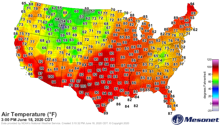
I came across this image on Twitter and just had to share it.

This afternoon, the hottest place east of the Mississippi river was in Northern Maine!
Image
3:00 PM Air Temperatures
Click on the image to further examine how warm it is in northern New England. Why are we seeing this incredible warmth? We can blame a cutoff low that is sitting in the mid-atlantic right now, causing tropical air to rest in the northeast. That 94 that you see in Northern Maine sure is something!

I'll have an update on my travels when I arrive home.

Sunday, June 14, 2020

Quick Update on My Travels

Hi everyone! Happy Sunday.

I have arrived here in Nantucket and the weather has been spectacular, and it looks like it will be that way for the entire week that I'm here.

Here's a look at the CT coastline from the plane yesterday.
CT Coastline
And here's a shot of Children's Beach on the island that I took yesterday.

Children's Beach
Overall, not much to talk about weather wise for the week throughout New England. It'll simply be spectacular. It's interesting to examine how people are taking social distancing here on the island. I'd say about 50% of people are wearing masks, while many are not. People are spread out on the beaches, which is good to see.

Have a great Sunday!

Friday, June 12, 2020

Snow...

Happy Friday, everyone! I hope you've found a way to enjoy this spectacular weather day! I'll be traveling over the next week, so my posts on this blog may be a little sporadic over the next few days. But I'll be sure to post about my trip when I return.

Hopefully you didn't get worried by the title of this post. No, it's not going to snow here in New England any time soon, but I did want to mention a few things related to snow, my favorite type of weather.

First, it snowed in Canada today. That's right. On June 12th Canada saw some accumulating snowfall. Here's a look at what they saw.
Snow Precipitation for 6/12 (NOAA)
That area of color in Canada (which comes fairly close to Minnesota and the Great Lakes) is where snow has fell overnight last night into today. And it looks like some areas could have seen almost an inch or two! That's exciting for an area not at elevation for this time of year.

Secondly, heres a look at the country's snow depth map.
Current Snow Depth (NOAA)
While most areas by now have lost their snow pack, places in the Rockies and Cascades (the usual culprits for a deep snowpack) are still holding on to some considerable snow depth. It'll be interesting to see how long this remains and its implications for water in the west, which is struggling with a drought right now.

Sorry for posting about snow in the middle of June, but it's simply something that I love to talk about! 

Enjoy the weekend, and I'll do my best to keep the blog updated as I travel.

Thursday, June 11, 2020

Friday Forecast

My apologies for the later post today. I wanted to talk about the heavy rain and thunderstorms that we have been seeing throughout the day, but I haven't gotten around to posting until just now.

Instead, I'm going to provide a quick forecast for tomorrow.

You probably have felt yesterday and today's humidity, but that's all to change as we head into the weekend, starting with a beautiful day tomorrow.

As you can see in this dew point map, there is a large and drier airmass that will be moving into the region overnight tonight. The distinction between the oranges and the greens is the distinction between humid and more refreshing air.
NAM 2 a.m. Friday dew point (Tropical Tidbits)
And by 2 p.m., that more refreshing, dry air has made its way completely into the region, making it feel fantastic!
NAM 2 p.m. Friday dew point (Tropical Tidbits)
As for temperatures, expect comfortable conditions, with temps reaching the upper 70s to low 80s. That, coupled with abundant sunshine will make tomorrow a great day for outdoor activities like going to the beach.
NAM 2 p.m. Friday Temperature (Tropical Tidbits)
Overall, Friday will be the choice day for the weekend, so get out and enjoy it!

Wednesday, June 10, 2020

Summer Solstice Info

If you feel like the days have been getting longer, you certainly are not wrong!

We are just 10 days away from this year's summer solstice, which will officially happen on June 20 at 5:43 p.m. eastern time. Scientifically speaking, the summer solstice occurs when the earth's north pole has its maximum tilt towards the sun. For us in the northern hemisphere, this is the day of the calendar year when we receive the most hours of daylight.

This image nicely displays the process that occurs on the summer solstice:
Summer Solstice Diagram (timeanddate.com)
That dashed line that you see in the image goes from the sun directly to the Tropic of Cancer, which receives direct sunlight on the summer solstice. The Tropic of Cancer is located at a latitude of approximately 23.5 °N.

For us in CT, the sun will rise at 5:18 a.m. and set at 8:30 p.m. on the summer solstice.

In Burlington, VT, the sun will rise at 5:08 a.m. and set at 8:41 p.m. on the solstice.

The slightly longer hours of daylight in VT is due to its further north latitude. The days will continue to get longer for the next ten days, and then the days will gradually get shorter as we head back towards fall and winter!

Tuesday, June 9, 2020

Could We be Heading Towards a Drought?

Good morning! Today will be another spectacular day! Get out and enjoy it.

I took a look at some drought data this morning, and we have some areas in the region that are abnormally dry. Here's a look at the Northeast Drought Monitor:
Northeast Drought Monitor (National Drought Mitigation Center)
We can see that while most of the region does not have any immediate risk of drought, but some places in Northern New England are in that "Abnormally Dry" category right now.

Interestingly, if we look at the data below, we can se that we've gradually been heading towards drier conditions.
Drought Conditions Data (National Drought Mitigation Center)
In just one week, the percentage of our region that is part of the "Abnormally Dry" has increased from 5.35% to 8.76%.

Fortunately though, the Climate Prediction Center's (CPC) seasonal drought outlook lists no major threat for a drought developing in our region during the summer.
Seasonal Drought Outlook (CPC)
On the other hand, much of the American West is experiencing drought conditions that'll continue throughout the summer.

I believe more data will be released today, so we can see if more of are region joins the "Abnormally Dry" category, heading towards a drought.

Monday, June 8, 2020

Beautiful Day on Tap

Quick post today - it will be spectacular out there!

Here's a photo that I took this morning overlooking I-84 in Middlebury, CT, showing clear skies with plenty of sunshine.
Overlooking I-84 in Middlebury, CT this morning
Current temperatures sit in the upper 50s right now and the air is quite refreshing this morning.
Current Temperatures (Weather Central)
Temperatures will look to rise to the mid 70s later this afternoon, which is fairly seasonable conditions for this time of year.
5 p.m. eastern temperatures (Tropical Tidbits)
And the big reason it will feel so nice out today is the low dew points, which will only be in the 40s!
5 p.m. eastern dew points (Tropical Tidbits)

Overall, it will be a spectacular start to the work week with plenty of sunshine and refreshing air, so get out and enjoy it!

Sunday, June 7, 2020

May/2020 Weather and Climate Recap

This will be my last post recapping May 2020 weather, and I'll take a look at the year's weather so far.

First, here is the average mean temperature for the month of May, observed on a percentile scale. This means that if you see a 100, May 2020 was warmer than 100% of Mays in recorded history and if you se a 1, May 2020 was warmer than 1% of Mays in recorded history.
Average mean temperature percentiles for May 2020 (Northeast Regional Climate Center)
Evidently, it was quite cool in the Mid Atlantic, but as you head further north, things warmed up compared to normal. Here are the values for those average mean temperatures in °F.
Average mean temperatures for May 2020 (Northeast Regional Climate Center)
As far as 2020 goes, the story is much different. Here's the same map as the first one (the percentile one), but for the year to date so far.
Average mean temperature percentiles for 2020 (Northeast Regional Climate Center)
2020 thus far has been in the 80th or 90th percentiles for almost all stations in the Northeast, meaning it surely has been hot when compared to normal! I think this is particularly due to a warm winter that we had, given that April and May were so cold this year. And it looks like that warm trend for the year will continue. Here is the Climate Prediction Center (CPC) three month outlook for temperature, which was released on May 21. The colors indicate probabilities that temperature will be above or below normal, and any red areas are places that the CPC expects to have above average temperatures over the next 3 months.
3 month temperature outlook (CPC)
Put simply, the CPC expects it to be a hot summer, which will likely make us continue to have one of the warmest years on record here in the Northeast.

Enjoy your Sunday!

Saturday, June 6, 2020

Cooler Air Incoming

Today will feel quite hot as we'll see temperatures in the mid to upper 80s with high, muggy dew points as well. Here is a look at NAM temperatures for this afternoon. Those areas of red are hot air!
NAM 2-m temperatures for 2 p.m. eastern Saturday (Tropical Tidbits)
That's all to change as a cold front moves through and temperatures begin to drop as we head into the new work week.

Sunday is sort of that transitional day, as temperatures have dipped into the 50s and 40s in spots, a refreshing change from the heat we've been seeing.
NAM 2-m temperatures for 2 a.m. eastern Sunday (Tropical Tidbits)
Notice how different the two NAM maps look, even though they are only 12 hours apart! And by Monday morning we're even cooler, with temperatures having dipped into the 30s in spots.
NAM 2-m temperatures for 5 a.m. eastern Sunday (Tropical Tidbits)
Enjoy the warm (but muggy) weather today, and have a great weekend!

Friday, June 5, 2020

Climate Change

Happy Friday!

I've come across a few graphs and maps over the past few days that show that climate change is truly happening, so I wanted to share them with you all.

First, despite the reduction of travel due to COVID-19, CO2 levels are currently at their highest level in recorded history.
Atmospheric CO2 in Parts Per Million (PPM) (NOAA)
Atmospheric CO2 is now at a new high of just above 417 parts per million (PPM), as shown in the above graph based on data recorded at Mauna Loa Observatory in Hawaii. CO2 levels typically peak in May each year, and what's interesting is that the levels continued to rise this year despite a large-scale reduction of travel because of COVID-19.

The National Weather Service (NWS) uses 30 year climate norms when considering what is "average". So when reporting how far a temperature is compared to average, it will look at a 30 year period of temperatures. Right now, we are still comparing to the period from 1981 to 2010, but that'll change after this calendar year as we begin to compare to climate data from 1991 to 2020.

One of my favorite climatologists, Brian Brettschnieder, created two neat maps to show how these climate normals will change after this calendar year.
Places where climate normals will be warmer or cooler (Brian Brettschnieder)
In the above map, all those places with red dots are places that we can expect climate normals for 1991-2020 to be warmer than 1981-2010, so the only area that will be cooler is central Canada.

Difference between 1991-2020 and 1981-2010 climate normals in °C (Brian Brettschnieder)
This map shows the difference between 1991-2020 and 1981-2010 climate normals in °C, and it is quite clear that Europe has been very hot over the past 10 years (the years that were not included in the 1981-2010 normals). And those places in central Canada that will be cooler in the upcoming new normals will only be slightly cooler than the previous climate normals.

Sadly, this is more evidence that the globe is warming and climate change is happening.

Thursday, June 4, 2020

May Review for BDL

This post is a similar one to the May weather review that I posted for BTV, but for Bradley International Airport in Hartford, CT.

May 2020 daily data for BDL (xmACIS) 


The average temperature for the month was 70.5 °F, when the normal mean temperature is 71.2 °F, giving us an average temperature departure of -1.1 °F, so we were slightly cooler than normal. As for precipitation, we saw 20 days with a trace or more of precipitation, though we only saw 1.62 total inches, when normal is 4.35 inches, so it was a rather dry month.
Daily temperature graph for BDL for May 2020 (xmACIS)
The above graph shows temperatures for the month at BDL. Notice that we were quite cold and below the normal temperature range at the start of the month, but we warmed up towards the end of the month.

A highlights for the month include the trace of snowfall that we saw in early May since May is very late to see any snow in CT. We set a new May 11 record minimum temperature, when the temperature dropped to 31 °F. I'd say May 2020 was somewhat abnormal, with cool temperatures and much below normal precipitation for BDL.

I'll post about May and 2020 on a global scale in future posts.

Wednesday, June 3, 2020

Busy Weather Day Today

Today will be a fairly active weather day throughout the country.

Here is a look at the Storm Prediction Center (SPC) outlook for today with areas in color showing a risk for storms.
SPC 1 day outlook for today (NWS)
The biggest risk is in the New Jersey area, where we have already seen some storms with large hail and damaging winds today (sorry about the later post today). For us in New England, the biggest risk for some afternoon storms will be in southernmost areas like Fairfield County, CT.
GOES-East view at 2 p.m.
The above image shows a NASA GOES-East satellite where the big storm clouds have now moved off the New Jersey coast. We're cloudy here in New England now, but we can expect some convection to pop up in spots this afternoon.

Here is radar showing that storm that was hitting the mid-atlantic states hard earlier today.
Radar at 2:48 p.m. eastern time (NWS)
I don't see us having too much risk for severe storms today, but it'll be something to keep an eye out for as convection can pop up fairly quick.