Thursday, April 30, 2020

Weekend Outlook

Happy Thursday and last day of April, everyone! This weekend's weather will be a crescendo of sorts, with the weather turning from nasty tomorrow morning to absolutely beautiful on Sunday!

Tomorrow morning, we can see an area of low pressure sitting in Pennsylvania, which will move out to sea late Friday. Rain will progressively work its way out of the Northeast throughout the day tomorrow.
Friday morning NAM outlook showing rain (Tropical Tidbits)
By Saturday, that rain has fully moved out of the region, and we have a nice day in store, with sunny skies.
Saturday afternoon NAM - clear in the region (Tropical Tidbits)
And the cherry on top for the weekend comes on Sunday, when we could crack 70 degrees F here in New England, and we'll see sunny skies. This will feel quite warm, given how cold it has been during the month of April, but average high temps for this time of the year are actually in the upper sixties, so we'll be right around normal for the high.
Sunday afternoon temperatures from the GFS model (Tropical Tidbits)
Have a super weekend!

Wednesday, April 29, 2020

Quick Look at Mt. Mansfield Snow Stake

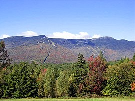
Being the snow lover that I am, I always find it fun to look at the summit snow stake on Mt. Mansfield to see where the snow depth sits during the winter. Mt. Mansfield, located in Underhill, VT, is Vermont's tallest mountain with a summit elevation of 4,393 feet. Here's a fall image of the mountain:
Mount Mansfield - Wikipedia
Mt. Mansfield in the Fall (Wikipedia)
The snow stake, which actually sits below the summit at an elevation near 3,900 feet, has collected snow depth records for the mountain since the winter of 1955. Data are obtained by the National Weather Service using electronic monitoring devices. Some interesting historical data can be seen at the site: https://waw.w3.uvm.edu//skivt-l/?Page=mansel.php 

Today, April 29, we sit at a snow depth of 69 inches, and the average for April 29 is 51 inches, so we're well above average for this time of year.
Mt. Mansfield snow stake data for 4/29, 2020 (SkiVt-L)
You can clearly see the uptick in snow depth after the snowfall this past weekend. With cool temperatures forecasted into early May, we'll look to retain a fairly large snowpack on the mountain that could last into June!

Tuesday, April 28, 2020

Summer Outlook

Today is a quiet weather day here in New England, with seasonable temperatures and sunny skies. With that in mind, I thought I'd look ahead to this summer, and see what early outlooks predict for what is in store weather-wise.
Probabilistic outlook for above and below normal temperatures this summer.
The above map, released on April 16th by the Climate Prediction Center (CPC) shows a probabilistic temperature outlook for this summer. All that red you see represents locations where temperatures have a higher probability of being above normal. Certainly, an outlook released this far in advance must be taken with a grain of salt, but it'll be interesting to see if this verifies and we'll have a warm summer here in New England.
Probabilistic outlook for above and below normal precipitation this summer.


This map is a similar one, only showing the probability of above and below normal precipitation this summer. Eastern areas look to be favored for a wetter than normal summer, while areas in the West look to be more dry.

Both of these maps must be taken with a grain of salt, but it's always interesting to speculate about what our weather will look like this summer!

Monday, April 27, 2020

Nice Day Tomorrow + look at yesterday into today's storm

Tonight's post is a quick one since I'm pretty busy. Basically, we'll see a beautiful, spring like day tomorrow! It'll be a great day to get outside, though hopefully people continue to practice social distancing. It will certainly be interesting to see how people follow social distancing guidelines as the weather continues to get nicer and people are itching to get outside.

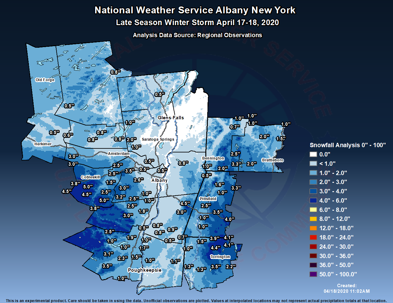
Yesterday's "snowstorm" brought snow to portions of the Northeast. Here's a snowfall analysis from the National Weather Service in Albany.

Higher elevation areas were clearly favored with this storm. and we can see that snow totals were less as you approach Lake Champlain.

And for your additional reading, here's a great article that I came across about wacky Denver weather and climate:

Sunday, April 26, 2020

Outlook for the Week

I'm sorry to say, but this week is not looking nice weather-wise. Today has been a washout throughout New England, with heavy rain, strong winds and cold temperatures.  The rain continues throughout tomorrow, so it'll be another good day to stay at home. Here's a look at tomorrow morning, and we can see that'll still be pretty rainy with snow at the higher elevations of Northern New England.
I think this map (the GFS) is a little overdone snow-wise, and it's really only the highest elevations of N.E. that'll see significant snow.

This map, for the afternoon, shows the rain trying to clear in spots, but it'll still be around.

And Tuesday looks like the nicest day of the week, as we'll finally see clear skies.


Other than Tuesday, this week can be summed up by rain and cool temperatures, though Wednesday could be a little more clear. Overall, not to much to look forward to weather-wise this week.

Saturday, April 25, 2020

Mt. Mansfield Snow Stake Update

I hope you all enjoyed the glorious spring weather that we had in New England today.  Temperatures were much more seasonable than they have been, but that changes as we head in to the work week as the weather looks somewhat nasty. I'll update on that topic tomorrow.  Here's a nice photo of the sunrise over I-84 in Middlebury, CT that I caught early this morning.


Given the unseasonably cold weather we've seen over the past few weeks, I wanted to take a look at the snow depth atop Mount Mansfield, Vermont's highest peak, as shown by the Mount Mansfield Snow Stake:


The graph shows that snow depth peaked on around March 1st this year, and then quickly plunged back down during the warm March that we had.  Later on in March, the snow depth has hit a plateau, due to the colder weather we've seen, which has prevented snow melt.  And with some snow forecasted for this weekend, it'll be interesting to see if this depth can actually increase. 

Friday, April 24, 2020

Climate Patterns for BDL, BTV

It's certainly felt like a cold, wet month here in New England. I decided to look at some climate records today, to see where we "should" be this time of year.  In other words, what would average look like on this day. First, here's a look at Bradley International Airport in Windsor Locks, CT.
These records date back to 1949, and the maximum temperature "should" be 64 degrees F, and the minimum temperature "should" be 41 degrees F. We've definitely been colder than that here in CT. In fact, the normal Avg temperature to date this month is 48.3 degrees F and so far this month the average temperature has been 45.8 degrees F.  

Here's a look at Burlington International Airport (BTV) data in Burlington, VT:
Records here date back to 1940, and in Burlington, the temperature "should" reach 59 degrees F daily, with lows at 38 degrees F.  Again, we've certainly been colder than that. And the departure from normal for the avg monthly temperature to date is 1.4 degrees below normal, which is not quite as big as the 2.5 degrees below normal that we've had in Connecticut.

It'll be exciting to see how the rest of the month plays out!

Thursday, April 23, 2020

Snow To Come?

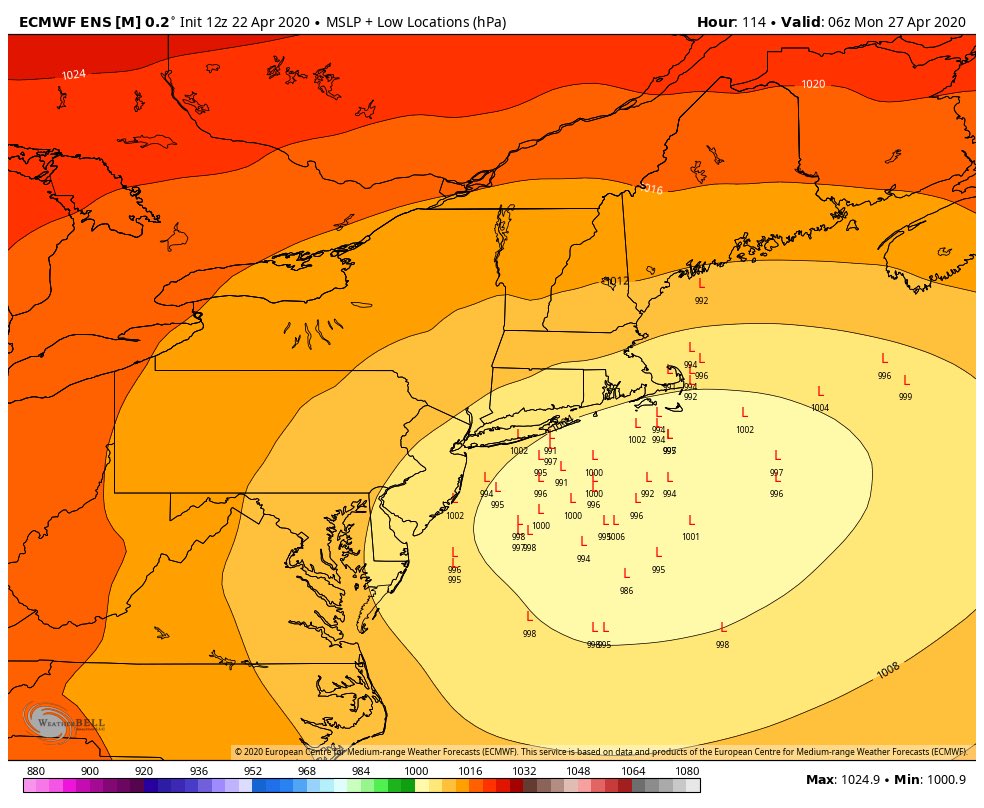
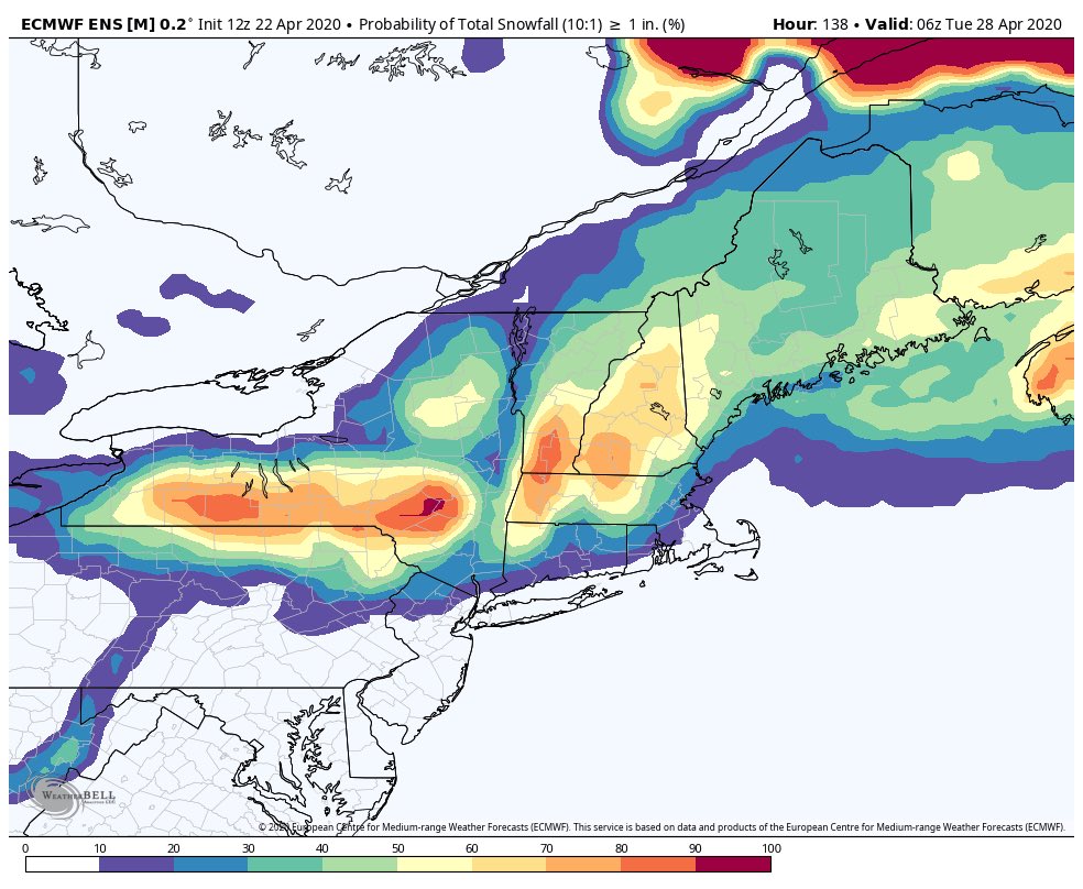
As we've been tracking all along, this spring has been abnormally cool here in New England.  And as I posted about a few days ago, that cold looks to stick around for the near future.  However, what I did not mention is the potential for some snow this Sunday.  While it is abnormally late in the season for snow, interior parts of New England (think Vermont, New Hampshire, the Berkshires) could see some snow this weekend if all goes right.  (The following images each show the European Model).

Image

We can see that a low pressure system will be tracking of the Connecticut and Rhode Island coastline, an ideal track for a big wintertime snow storm.

Image

This map snows the probabilities of areas receiving greater than or equal to 1 inch of snow.  We can see that the Northern Berkshires and Southern Vermont are favored here.

Image

And lastly, here's a look at accumulated snowfall through Tuesday, assuming a 10:1 snow ratio.  I think these totals may be overdone in spots given how late it is in the season (I'm thinking climatologically here), but we can't rule out the possibility for some snow piling up in parts of New England this weekend. We'll have to wait and see!

Wednesday, April 22, 2020

Earth Day Musings

Today, April 22, marks the 50th anniversary of Earth Day, which is in my opinion, one of the best days of the year. We're luck to have so many valuable resources and be citizens of this great planet, and it is our duty to protect it.  Now, more than ever, the future of this world is in our hands, and we have the power to make it a great future for our children and our children's children. So take some time today to reflect on why you're grateful to live on this earth, and do something good for it. Here are some photos showing why earth is so incredible to me.
Incredible rock faces in Zion National Park, UT

An Arch near Lake Powell, UT

Antelope Canyon in AZ

A sunset overlooking a farm in Middlebury, VT

Beautiful Rocks in Mallorca, Spain
A sunrise in Middlebury, CT


A glacier in Zermatt, Switzerland

The Matterhorn in Switzerland

Fall foliage in southern VT

I love planet earth!

Tuesday, April 21, 2020

Fun Weather Day!

Today was certainly a fun weather day in New England.  We started early this morning with hail in southeastern CT, and after quieting down in the morning, the wild weather really got going in the afternoon.  Throughout New England, we saw hail, damaging winds, thunder and lightning, heavy rain, snow, and then a beautiful sunset to cap it off! That's April for you.


Here are some images of the hail that I took at my house in Middlebury, CT.
 

And here's a look at radar from this afternoon.  Notice the severe thunderstorm warnings and the line of intense heavy storms.  Large hail was reported in New Jersey at this time, according to radar.


Now that the storm is done, we'll look ahead to a frigid morning tomorrow with cold wind chills - though skies will be sunny!

Monday, April 20, 2020

Climate Outlook

Today is a fairly quiet day in New England weather, with most areas seeing cool temperatures and cloudy skies. Cape Cod has seen some rain, but other than that, we've been dry and cloudy.  I thought it would be a good day to look ahead in the next 2 weeks to see how temperatures and precipitation will look.

First we'll take a look at NOAA's Centers for Climate Prediction (CPC) 6-10 climate outlook released today (April 20). The large area of red on the map is where temperatures will be above average over the next 6-10 days, and the blue shows areas that'll be below average.  So the big story is cool in the East and hot out West.  As far as precipitation goes, the map on the right shows that we'll be on the wetter side in New England, while the rest of the country remains dry.

And just for fun, here's a look at the same maps, out to 8-14 days. This cold and wet pattern looks to remain in place.  If this were winter, we'd be in for a snowy one, but of course it comes during April.

 
That's all for today, tomorrow I'll look at the storm threat in the northeast... could be a fun weather day!

Sunday, April 19, 2020

April Snowstorm Part 2

Here's a closer look at climate data, so we can understand how abnormal (or not) this April snowstorm was in CT.

Image

This image from the National Weather Service in Albany shows snow totals from the storm. Highest totals were around half a foot.

These data show the latest day in the calendar year when an inch or more of snow was recorded at Bradley International Airport in Windsor Locks, CT. May 5 is the latest.

And here's a look at the maximum 1 day snowfall at Bradley on days later than April first.
So while this storm certainly was abnormal, it's not unheard of to get snow in New England this late in the year, as Bradley saw 14 inches on April 6, 1982!

Saturday, April 18, 2020

April Snowstorm

We had a late season snowstorm here in southern New England this weekend, with some heavy, wet snow falling. This one was very elevation and geograpically-dependent, with some areas seeing over a half a foot, while nearby areas barely saw a coating. My house saw some flakes throughout the morning, and this was the most exciting photo of the storm I could take.

Here's a map of the snowfall throughout New England.  Clearly, northwest areas in Connecticut were favored in this storm.

The snow won't last long (if it's still around even), as the high sun angle this time of year will melt the snow quickly and it was already a wet snow to begin with. Additionally, tomorrow will feel more spring-like as temperatures approach 60 and skies will be sunny. Tomorrow will be a great day to get outside!

I'll look into some climate data in tomorrow's post to see how abnormal a snowstorm this time of year is in the northeast.

Friday, April 17, 2020

Overview

Hi all!  Welcome to this new blog, Addison County Weather Watchers!  My name is Michael Wasserstein, and I'm a student at Middlebury College.  In this blog, I'll be posting about all things weather and climate, particularly in Addison County, VT and my home state Connecticut.  I absolutely love talking about weather, so any opportunity I can get to talk about it, I'm gonna take.  My goal is to post daily about any relevant weather, climate, geological, astronomical, science, etc. topics. I'll also do posts on my instagram @addisoncountyweatherwatchers , but these blog posts will go more in depth than the instagram posts.  It'll be exciting to have you all following along!

Follow my social media accounts:

Twitter @MichaelWassers1     https://twitter.com/MichaelWassers1

Instagram @addisoncountyweatherwatchers 


And just to kick things off, here's a picture of me in my favorite type of weather, snow!


This one's from February 9, 2013, when Connecticut received a massive snowstorm, with up to 40 inches in areas.  That was certainly one of the most exciting weather moments of my life.