Monday, May 11, 2020

Winter Straight to Summer

Wow! That was a wild weekend in the weather world. We saw rain, snow, graupel, sun, record-setting cold, and a thunderstorm with hail today to top it all off! There's nothing quite like weather in New England.

Speaking of strange weather, it has been quite cold compared to normal for some time now, and we're looking at a big time pattern shift in the next week which will bring some warmer weather with it. Here's the Climate Prediction Center's (CPC) 6-10 day temperature outlook.
CPC 6-10 Day Outlook made on May 11, 2020 (NWS)
Essentially, all the red areas in the above map are areas where the temperature will probabilistically be above normal, and the blue areas are spots where the temperature will probabilistically be below normal. This map is created for 6-10 days out, so it is for May 17-21.

And the 8-14 day outlook shows more of the same, with an extremely hot area centered around West Virginia.
CPC 8-14 Day Outlook made on May 11, 2020 (NWS)

This map includes Memorial Day (May 25), so it's certainly possible that we'll be in for a warm holiday this year. With the swing from intense cold to above normal temperatures, it's almost like we're skipping spring altogether this year!

Sunday, May 10, 2020

Climate Normals For May 10

Happy Mother's Day to all!

Today's post is a quick one about the weather that we should be seeing for May 10, based on many years of climate records. Temperatures in Burlington, VT reached a high of 41 °F yesterday. We can see in the image that highs for this time of the year should be 65 °F, so it was really cold yesterday!

Climate Data for BTV for May 10, 2020 (xmACIS)
And for Hartford we hit 48 °F yesterday, when normal should be 70 °F. This really shows how unseasonably cold it is right now!
Climate Data for BDL for May 10, 2020 (xmACIS)

Saturday, May 9, 2020

Snow Recap

The overnight storm was very elevation and location dependent, with some areas seeing nearly a foot of snow and others nearby seeing only a trace. Unfortunately, I only saw remnants of the snow on my roof and mailbox this morning. I simply live too far south to see any true accumulations today. Here are some photos from the storm. Thanks to those that contributed!


My mailbox in Middlebury, CT
3 inches in Richmond, VT from Jonathan Fisher
A beautiful shot in Middlebury, VT (Eli Miller)
Armonk, NY(Alyssa Berkman)

A trace of snow in New Preston, CT (Marty Wasserstein)

Those that contributed from VT clearly had the most snow from this one. Here are some National Weather Service graphics displaying snowfall totals.

Snow totals for Northern New England (NWS Burlington)

Snow totals for Northern New York, Southern VT, Western MA and CT (NWS Albany)
While snow this late in the year in the Northeast is uncommon, it's certainly not unheard of. On May 9-10, 1977, parts of Connecticut got 20 inches of snow, and on May 26-27, 2013 (Memorial Day Weekend), Whiteface Mountain in the Adirondacks of New York saw 3 feet of snow. While the cold will stick around for the next few days, I think that we can safely say that we'll be done with snow for the year.

Friday, May 8, 2020

Snow Incoming

I posted earlier this week speculating about if we'd see any more chances for snow this spring, and threw in a large IF with that post. Well, it looks like we will see a bit of snow this weekend!

This one starts as rain this afternoon, which turns heavy in the early evening hours.
HRRR showing heavy rain in Southern New England early this evening (Tropical Tidbits)
The transition to snow comes earliest in Northern New England, and occurs at around midnight for the western hill towns of Southern New England.
NAM showing snow in parts of New England around midnight (Tropical Tidbits)

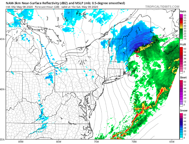
By Saturday morning when you're waking up, the snow will have worked its way into NH and Maine, dumping some heavy snow at times.
NAM showing heavy snow in Maine early Saturday morning (Tropical Tidbits)
This storm is a pretty quick mover, and if you're a late riser and depending on where you live, you might not see anything accumulation-wise. When all is said and done, we'll be looking at a coating to 2 inches of snow for most areas, though portions of NH and Maine could see more significant accumulations. Here's what the National Weather Service is thinking accumulation-wise.
Forecasted snow totals (NWS Eastern Region)
Temperatures will be impressively cold for May with this storm, and winds will be gusty during the day on Saturday. This storm is certainly exciting for May, and I'll unpack it when it's all said and done. If you have any photos of accumulation, send them in to be featured!

Thursday, May 7, 2020

Daylight

You probably notice that the days feel much longer now, and you're correct!

Taking Hartford, CT as my point of reference, here are some fun facts related to the amount of daylight.

When quarantine began for most (around May 15), Hartford's sunrise was at 7:01 a.m., and the sun set at 6:57 p.m., giving us 11 hours, 56 minutes of daylight.

Saturday, March 20 was the vernal equinox, and we had 12 hours, 10 minutes of daylight on this day.

And today, May 7, the sun rose at 5:39 a.m. and it'll set at 7:56 p.m., giving us a full 14 hours 16 minutes of daylight.

It's only 44 days until the summer solstice, when we start to lose daylight. On this day, the sun will rise at 5:16 a.m. and set at 8:28 p.m.

Take advantage of all this extra daylight we have now!

Wednesday, May 6, 2020

Cold Incoming

We'll see some impressive cold this weekend, and potentially some record low temperatures for May.

Image
The european model showing a 5 day temp. anomaly through May 11 (Weather Bell)
The above map shows the European Model's 5 day temperature anomaly through May 11, and temperatures will be well below normal through this period as a whole.

Here are temperatures for Saturday afternoon, with the NAM showing temperatures only reaching the 40s. That's incredibly cold for May in New England!
NAM Saturday afternoon temperatures (Tropical Tidbits)
And lastly, the GFS' overnight temps for Friday into Saturday, with many areas in the 20s, and some places in the Appalachian mountains easily in the teens.
GFS overnight temps Friday into Saturday (Tropical Tidbits)

This cold is all do to a large airmass that is dipping down from the arctic, and if it were January, we'd be in for some absolutely frigid temperatures. Stay warm!

Tuesday, May 5, 2020

Weather book recommendations

I thought I'd mix things up on this fairly quiet weather day, and share some of my favorite weather-related books:


"The Weather Machine: A Journey Inside the Forecast" - Andrew Blum


The Weather Machine: A Journey Inside the Forecast by [Andrew Blum]
This well-researched book by Andrew Blum provides a very good overview of what goes into weather models and how they were created.

https://www.amazon.com/Weather-Machine-Journey-Inside-Forecast/dp/0062792156


"Appropriating the Weather : Vilhelm Bjerknes and the Construction of a Modern Meteorology" -Robert Marc Friedman
Appropriating the Weather: Vilhelm Bjerknes and the Construction of a Modern Meteorology (Cornell History of Science Series)


This book dives deep into the science and work of Vilhelm Bjerknes to develop modern forecasting techniques.

https://www.amazon.com/Appropriating-Weather-Bjerknes-Construction-Meteorology/dp/0801420628/ref=sr_1_1?dchild=1&keywords=appropriating+the+weather&qid=1588715486&s=books&sr=1-1

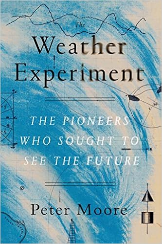
"The Weather Experiment: The Pioneers Who Sought to See the Future" - Peter Moore

This one covers some nice history of early meteorology.


"Inventing Atmospheric Science: Bjerknes, Rossby, Wexler, and the Foundations of Modern Meteorology" - James Rodger Fleming
Inventing Atmospheric Science: Bjerknes, Rossby, Wexler, and the Foundations of Modern Meteorology (The MIT Press) by [James Rodger Fleming]
This one covers some specific topics that "Appropriating the Weather : Vilhelm Bjerknes and the Construction of a Modern Meteorology" does, but does so with a more historical/ less scientific approach.


I regret to say that I haven't dug deep into any meteorology textbooks, but that is a goal of mine for this summer.